| Mahatma Gandhi Marine National Park (M.G.M.N.P) | |
|---|---|
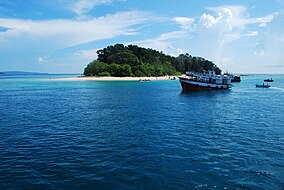
 This is the Mahatma Gandhi Marine National Park near Port Blair, Andaman Islands. Its popularly known as "Jolly buoy" islands. | |
 | |
| Location | Andaman Islands, India |
| Nearest city | Wandur |
| Area | 281.5 km2 (108.7 sq mi) |
| Established | 1983 |
Nickname: North Mahatma Gandhi Islands | |
|---|---|
| Geography | |
| Location | Bay of Bengal |
| Coordinates | 11°32′N 92°36′E / 11.53°N 92.60°E |
| Archipelago | Andaman Islands |
| Adjacent to | Indian Ocean |
| Total islands | 17 |
| Major islands |
|
| Area | 29.043 km2 (11.214 sq mi)land area |
| Highest elevation | 78 m (256 ft)[1] |
| Highest point | Tarmugli Island |
| Administration | |
| District | South Andaman |
| Island group | Andaman Islands |
| Island sub-group | Rutland Archipelago |
| Tehsil | Port Blair Tehsil |
| Largest settlement | Jolly Buoy Beach |
| Demographics | |
| Population | 0 (2011) |
| Additional information | |
| Time zone | |
| PIN | 744103[2] |
| Telephone code | 031927 [3] |
| Official website | www |
| Census Code | 35.639.0004 |
| Official Languages | Hindi, English |
Mahatma Gandhi Marine National Park is a national park in India, near Wandoor on the Andaman Islands. It belongs to the South Andaman administrative district, part of the Indian union territory of the Andaman and Nicobar Islands.[4]
- ^ Sailing Directions (Enroute), Pub. 173: India and the Bay of Bengal (PDF). Sailing Directions. United States National Geospatial-Intelligence Agency. 2017. p. 278.
- ^ "A&N Islands - Pincodes". 22 September 2016. Archived from the original on 23 March 2014. Retrieved 22 September 2016.
{{cite web}}: CS1 maint: bot: original URL status unknown (link) - ^ "STD Codes of Andaman and Nicobar". allcodesindia.in. Retrieved 23 September 2016.
- ^ "Village Code Directory: Andaman & Nicobar Islands" (PDF). Census of India. Retrieved 16 January 2011.
