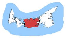
 Malpeque in relation to the other Prince Edward Island ridings | |||
| Coordinates: | 46°20′42″N 63°22′59″W / 46.345°N 63.383°W | ||
| Federal electoral district | |||
| Legislature | House of Commons | ||
| MP |
Liberal | ||
| District created | 1966 | ||
| First contested | 1968 | ||
| Last contested | 2021 | ||
| District webpage | profile, map | ||
| Demographics | |||
| Population (2016)[1] | 36,030 | ||
| Electors (2019) | 30,275 | ||
| Area (km²)[1] | 1,663 | ||
| Pop. density (per km²) | 21.7 | ||
| Census division(s) | Prince, Queens | ||
| Census subdivision(s) | Towns: Borden-Carleton Cornwall Kensington Villages: Bedeque, Brackley, Breadalbane, Central Bedeque, Clyde River, Crapaud, DeSable, Hunter River, Kinkora, Meadowbank, Miltonvale Park, Stanley Bridge, Hope River, Bayview, Cavendish and North Rustico, Union Road, Victoria, Warren Grove, Winsloe Park First Nations reserves: Rocky Point 3 Lots: Lot 18, 19, 20, 21, 22, 23, 24, 25, 26, 27, 28, 29, 30, 31, 33, 34, 65, 67 | ||
Malpeque is a federal electoral district in Prince Edward Island, Canada, that has been represented in the House of Commons of Canada since 1968. Its population in 2011 was 35,039.
Following the 2022 Canadian federal electoral redistribution, at the first election held after April 22, 2024. It will gain the remainder of North Shore and the North Shore Fire District, plus everything west of Highway 6 between them from Cardigan, lose the Bedeque area plus some areas east and southeast of Summerside, and lose newly annexed territory by the City of Charlottetown in the Marshfield area to Charlottetown.[2]
- ^ a b Statistics Canada: 2012
- ^ "New Federal Electoral Map for Prince Edward Island". Federal Electoral Districts Redistribution 2022. 23 March 2023. Retrieved 8 March 2024.