Manchester, Washington | |
|---|---|
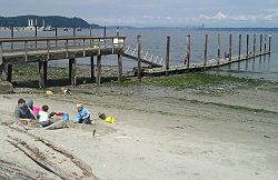
 The public pier and waterfront at Manchester during a summer low tide. Bainbridge Island is in the background on the left, and Seattle is far away on the right. | |
 Location of Manchester, Washington | |
| Coordinates: 47°33′8″N 122°33′0″W / 47.55222°N 122.55000°W | |
| Country | United States |
| State | Washington |
| County | Kitsap |
| Area | |
| • Total | 5.65 sq mi (14.64 km2) |
| • Land | 2.93 sq mi (7.58 km2) |
| • Water | 2.73 sq mi (7.06 km2) |
| Elevation | 30 ft (9 m) |
| Population (2010) | |
| • Total | 5,413 |
| • Density | 1,851/sq mi (714.6/km2) |
| Time zone | UTC-8 (Pacific (PST)) |
| • Summer (DST) | UTC-7 (PDT) |
| ZIP code | 98353 |
| Area code | 360 |
| FIPS code | 53-42450[1] |
| GNIS feature ID | 1512426[2] |
Manchester is an unincorporated community and census-designated place (CDP) in Kitsap County, Washington, United States. The population was 5,714 at the 2020 census.[3] Manchester is located on the Puget Sound approximately 10 miles from downtown Seattle, and is adjacent to county seat Port Orchard to its east. Today, Manchester labels itself as a village.[4] It is small in size but is home to a Kitsap Regional Library (KRL) branch, a post office, an elementary school, and a beachfront park to serve its residents.
- ^ "U.S. Census website". United States Census Bureau. Retrieved January 31, 2008.
- ^ "Manchester". Geographic Names Information System. United States Geological Survey, United States Department of the Interior.
- ^ "Quick Facts: Manchester CDP, Washington; United States". United States Census Bureau.
- ^ Library, Manchester Village: Friends of Manchester. "Welcome to Manchester Village". Manchester Village: Friends of THE Manchester Library. Retrieved January 25, 2022.