| Mandakini River | |
|---|---|
 | |
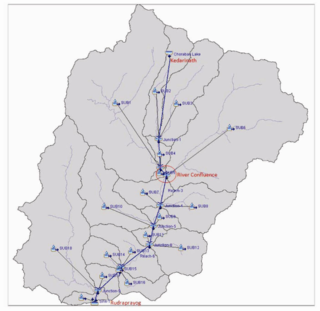
 Hydrological setup of the Mandakini showing its course through Kedarnath | |
| Location | |
| Country | India |
| State | Uttarakhand |
| Physical characteristics | |
| Source | Chorabari Glacier |
| • location | Kedarnath Summit, Kedarnath, India |
| • coordinates | 30°44′50″N 79°05′20″E / 30.74722°N 79.08889°E |
| • elevation | 3,895 m (12,779 ft) |
| Mouth | Alaknanda River |
• location | Rudraprayag, Uttarakhand, India |
• coordinates | 30°17′16″N 78°58′44″E / 30.28778°N 78.97889°E |
• elevation | 690 m (2,260 ft) |
| Length | 81.3 km (50.5 mi) |
| Basin size | 1,646 km2 (636 sq mi) |
| Discharge | |
| • average | 108.6 m3/s (3,840 cu ft/s) |
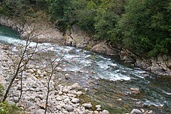
The Mandakini River is a tributary of the Alaknanda River in the Indian state of Uttarakhand.[1] The river runs for approximately 81 kilometres (50 mi) between the Rudraprayag and Sonprayag areas and emerges from the Chorabari Glacier.[2] The Mandakini merges with river Songanga at Sonprayag and flows past the Hindu temple Madhyamaheshwar at Ukhimath.[1] At the end of its course it drains into the Alaknanda, which flows into the Ganges.[1]
The Mandakini is considered by Hindus a sacred river within Uttarakhand as it runs past the Kedarnath and Madhyamaheshwar temples.[3][4] For this reason, the Mandakini has been the site of pilgrimages and religious tourism, with treks passing significant sites of spirituality such as Tungnath and Deoria Tal.[5] The Mandakini area also attracts millions of tourists annually for whitewater rafting, hiking, and religious tours around the winter Chardham being offered. In 2011, more than 25 million tourists visited the river (for comparison, the State of Uttarakhand has a population of about 10 million).[1][3][6] The health of the river and surrounding landforms have slowly been degraded, giving rise to environmental conservation projects such as the Kedarnath Wildlife Sanctuary.[7]
The Mandakini is subject to heavy rainfall, especially during monsoon season. The annual rainfall within the surrounding region is 1,000–2,000 millimetres (39–79 in), which is elevated almost 70% in monsoon season (late July–October).[8] This heavy rainfall is often responsible for rising water levels and intense flash floods.[2] In conjunction with the collapse of a segment of the dammed Chorabari Lake in 2013, an intense patch of heavy rainfall led to the historical devastation of rural villages and death of thousands of locals, pilgrims and tourists.[4] These are known as the 2013 Kedarnath flash floods.
- ^ a b c d Rawat, A; Gulati, G; Maithani, R; Sathyakumar, S; Uniyal, VP (20 December 2019). "Bioassessment of Mandakini River with the help of aquatic macroinvertebrates in the vicinity of Kedarnath Wildlife Sanctuary". Applied Water Science. 10 (1): 36. Bibcode:2019ApWS...10...36R. doi:10.1007/s13201-019-1115-5. ISSN 2190-5495.
- ^ a b "Mandakini River - About Mandakini River of Uttarakhand- Kedarnath flash flood". eUttaranchal. 18 December 2015. Retrieved 6 October 2020.
- ^ a b Kala, CP (1 June 2014). "Deluge, disaster and development in Uttarakhand Himalayan region of India: Challenges and lessons for disaster management". International Journal of Disaster Risk Reduction. 8: 143–52. doi:10.1016/j.ijdrr.2014.03.002. ISSN 2212-4209.
- ^ a b Bhambri, R; Mehta, M; Dobhal, DP; Gupta, AK; Pratap, B; Kesarwani, K; Verma, A (1 February 2016). "Devastation in the Kedarnath (Mandakini) Valley, Garhwal Himalaya, during 16–17 June 2013: a remote sensing and ground-based assessment". Natural Hazards. 80 (3): 1801–22. doi:10.1007/s11069-015-2033-y. ISSN 1573-0840. S2CID 131701213.
- ^ Bahl & Kapur, R&R. "Kedarnath Flash Floods: Did Anything Change After Five Years?". Youtube. Archived from the original on 19 December 2021.
- ^ Cite error: The named reference
:11was invoked but never defined (see the help page). - ^ Kansal, ML; Shukla, S; Tyagi, A (30 May 2014). "Probable Role of Anthropogenic Activities in 2013 Flood Disaster in Uttarakhand, India". World Environmental and Water Resources Congress 2014. pp. 924–937. doi:10.1061/9780784413548.095. ISBN 9780784413548.
- ^ Khare, Deepak; Mondal, Arun; Kundu, Sananda; Mishra, Prabhash Kumar (September 2017). "Climate change impact on soil erosion in the Mandakini River Basin, North India". Applied Water Science. 7 (5): 2373–83. Bibcode:2017ApWS....7.2373K. doi:10.1007/s13201-016-0419-y. ISSN 2190-5487.