Manning, North Dakota | |
|---|---|
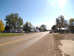
 Street in Manning | |
| Coordinates: 47°13′52″N 102°46′13″W / 47.23111°N 102.77028°W | |
| Country | United States |
| State | North Dakota |
| County | Dunn |
| Area | |
| • Total | 0.57 sq mi (1.49 km2) |
| • Land | 0.57 sq mi (1.49 km2) |
| • Water | 0.00 sq mi (0.00 km2) |
| Elevation | 2,221 ft (677 m) |
| Population (2020) | |
| • Total | 47 |
| • Density | 81.74/sq mi (31.58/km2) |
| Time zone | UTC-7 (MST) |
| • Summer (DST) | UTC-6 (MDT) |
| ZIP Code | 58642 |
| Area code | 701 |
| FIPS code | 38-50220 |
| GNIS feature ID | 2628576[2] |
Manning is a small town in, and the county seat of, Dunn County, North Dakota, United States.[3] Manning was founded in 1908 to serve as the seat of Dunn County, itself organized that year. Its population was not reported in the 2000 census,[4] but was included in the 2020 census, where a population of 47 was given.[5]
An unincorporated community, Manning, along with the surrounding inhabited vicinity, was designated part of the United States Census Bureau's Participant Statistical Areas Program on March 31, 2010, with the name of the Manning Census Designated Place[2]
- ^ "ArcGIS REST Services Directory". United States Census Bureau. Retrieved September 20, 2022.
- ^ a b c U.S. Geological Survey Geographic Names Information System: Manning, North Dakota
- ^ "Find a County". National Association of Counties. Retrieved June 7, 2011.
- ^ U.S. Census Bureau (2003). "Population and Housing Unit Counts, North Dakota" (PDF). 2000 Census of Population and Housing. Government Printing Office. Retrieved July 20, 2008.
- ^ "Explore Census Data". United States Census Bureau. Retrieved April 22, 2022.

