| Mansfield Hollow Lake | |
|---|---|
| Lake Naubesatuck, Mansfield Lake [1] | |
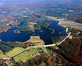
 Aerial view. Windham Airport can be seen at the right. | |
| Location | Mansfield & Windham, Connecticut |
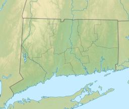
| Coordinates | 41°46′32″N 72°11′00″W / 41.77556°N 72.18333°W [1] |
| Type | Reservoir |
| Primary inflows | Natchaug River, Fenton River, Mount Hope River |
| Primary outflows | Natchaug River |
| Catchment area | 163 sq mi (420 km2) [2] |
| Basin countries | United States |
| Max. length | 2.2 miles (3.5 km) |
| Max. width | 2,400 feet (730 m) |
| Surface area | 440 acres (180 ha): Normal pool [2] |
| Max. depth | 23 ft (7.0 m) [2] |
| Water volume | 90,000,000 cubic feet (2,500,000 m3): Normal pool [3] |
| Surface elevation | 210 feet (64 m) [1] |
| Settlements | Mansfield Center |
| Mansfield Hollow Dam | |
|---|---|
 | |
| Official name | Mansfield Hollow Dam |
| Location | Mansfield & Windham |
| Construction began | 1949 |
| Opening date | 1952 |
Mansfield Hollow Dam | |
| NRHP reference No. | 03000194 |
| Added to NRHP | April 12, 2003 |
| Operator(s) | Army Corps of Engineers |
| Dam and spillways | |
| Impounds | Natchaug River |
| Height | 68 ft (21 m) |
| Length | 12,420 ft (3,790 m) |
| Width (crest) | 15 ft (4.6 m) |
| Width (base) | 265 ft (81 m) |
| Reservoir | |
| Creates | Mansfield Hollow Lake (Lake Naubesatuck) [4] |
Mansfield Hollow Lake is a reservoir resting on the border of Windham County and Tolland County, Connecticut. The reservoir provides drinking water for Willimantic and helps control flooding in the 159-square-mile Thames River watershed.[4] It was created by the Mansfield Hollow Dam and is entirely contained within Mansfield Hollow State Park and the Mansfield Hollow Wildlife Area.[5] Designed and constructed by the United States Army Corps of Engineers, the dam substantially reduces flooding along the Quinebaug, Shetucket, and Thames rivers. Construction of the project began in 1949 with completion in 1952 at a cost of US$6.5 million.[6] The Mansfield Hollow reservoir is located within the Shetucket River Watershed and is part of the Thames River Basin. Access to the site is available from US Route 6 and State Route 195. The damsite, covering an area of 25 acres (10 ha), was listed on the National Register of Historic Places in 2003.[7]
- ^ a b c "Mansfield Hollow Lake". Geographic Names Information System. United States Geological Survey, United States Department of the Interior.
- ^ a b c Cite error: The named reference
ctdepwas invoked but never defined (see the help page). - ^ Cite error: The named reference
usgs-wdr-ct-05was invoked but never defined (see the help page). - ^ a b Cite error: The named reference
courantwas invoked but never defined (see the help page). - ^ Cite error: The named reference
mapwas invoked but never defined (see the help page). - ^ Cite error: The named reference
usacewas invoked but never defined (see the help page). - ^ Cite error: The named reference
npgallerywas invoked but never defined (see the help page).
