40°49′17″N 82°31′0″W / 40.82139°N 82.51667°W
Mansfield Lahm Regional Airport | |||||||||||||||
|---|---|---|---|---|---|---|---|---|---|---|---|---|---|---|---|
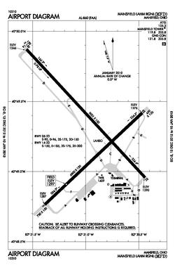 MFD diagram | |||||||||||||||
| Summary | |||||||||||||||
| Airport type | Public | ||||||||||||||
| Owner | City of Mansfield | ||||||||||||||
| Serves | Mansfield, Ohio | ||||||||||||||
| Location | Mansfield, Ohio | ||||||||||||||
| Elevation AMSL | 1,297 ft / 395 m | ||||||||||||||
| Website | https://www.ci.mansfield.oh.us/index.php/lahm-airport | ||||||||||||||
| Map | |||||||||||||||
 MFD  MFD | |||||||||||||||
| Runways | |||||||||||||||
| |||||||||||||||
| Statistics (2023) | |||||||||||||||
| |||||||||||||||
Mansfield Lahm Regional Airport (IATA: MFD, ICAO: KMFD, FAA LID: MFD) is three miles (5 km) north of Mansfield, in Richland County, Ohio. By car the airport is an hour away from Cleveland and Columbus, near Interstate I-71, US Rt 30, State Route 13.[2]
- ^ "Airport (Lahm)". The City of Mansfield.