Maple Creek | |
|---|---|
| Town of Maple Creek | |
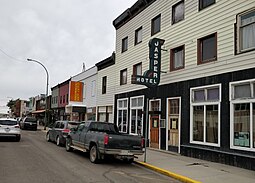
 The Jasper Hotel on Jasper Street | |
| Motto: "Where Past Is Present" | |
| Coordinates: 49°54′21″N 109°28′46″W / 49.90583°N 109.47944°W | |
| Country | Canada |
| Province | Saskatchewan |
| Rural municipality | Maple Creek |
| Established | 1882 |
| Incorporated (village) | 1896 |
| Incorporated (town) | April 30, 1903 |
| Government | |
| • Mayor | Michelle McKenzie |
| • Town Manager | Barry Elliott, CAO |
| • Governing body | Maple Creek Town Council |
| • MP | Jeremy Patzer |
| • MLA | Doug Steele |
| Area | |
| • Land | 4.42 km2 (1.71 sq mi) |
| Population (2016)[1] | |
| • Total | 2,084 |
| • Density | 471.3/km2 (1,221/sq mi) |
| Time zone | CST |
| Postal code | S0N 1N0 |
| Area code | 306 |
| Highways | Highway 21 Highway 271 Highway 724 |
| Railways | Canadian Pacific |
| Climate | BSk |
| Website | maplecreek.ca |
| [2][3] | |
Maple Creek is a town in the Cypress Hills of southwest Saskatchewan, Canada. It is surrounded by the Rural Municipality of Maple Creek No. 111. The population was 2,176 at the 2021 Census.
The town is 103 kilometres (64 mi) southeast of Medicine Hat, Alberta, and 40 kilometres (25 mi) north of the Cypress Hills Interprovincial Park on Highway 21 and 8 kilometres (5.0 mi) south of the Trans-Canada Highway. Maple Creek runs along the west side of town.
The administrative headquarters of the Nekaneet Cree Nation is 37 km (23 mi) southeast of Maple Creek.[4]
- ^ "2016 Census Profile". Statistics Canada. Government of Canada. Retrieved March 18, 2017.
- ^ National Archives, Archivia Net. "Post Offices and Postmasters". Retrieved June 1, 2014.
- ^ Government of Saskatchewan, MRD Home. "Municipal Directory System". Archived from the original on January 15, 2016. Retrieved June 1, 2014.
- ^ "Nekaneet - FHQ Tribal Council". fhqtc.com. Retrieved July 17, 2018.

