| Marcham | |
|---|---|
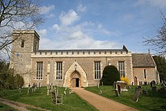
 All Saints' parish church | |
Location within Oxfordshire | |
| Population | 1,905 (2011 Census) |
| OS grid reference | SU4596 |
| Civil parish |
|
| District | |
| Shire county | |
| Region | |
| Country | England |
| Sovereign state | United Kingdom |
| Post town | Abingdon |
| Postcode district | OX13 |
| Dialling code | 01865 |
| Police | Thames Valley |
| Fire | Oxfordshire |
| Ambulance | South Central |
| UK Parliament | |
| Website | Marcham Parish Council |
Marcham is a village and civil parish about 2 miles (3 km) west of Abingdon, Oxfordshire. The 2011 Census recorded the parish's population as 1,905.[1] The parish includes the hamlets of Cothill 1+3⁄4 miles (2.8 km) east-northeast of the village, and Gozzard's Ford 1+1⁄2 miles (2.4 km) northeast of the village. Frilford and Garford used to be townships of Marcham parish,[2] but are now separate civil parishes. All these parishes were part of Berkshire until the 1974 boundary changes transferred them to Oxfordshire.
Marcham parish extends about 3+1⁄2 miles (5.6 km) north–south and up to 1+1⁄2 miles (2.4 km) east–west. It is bounded to the south by the River Ock and to the east largely by Sandford Brook, a tributary of the Ock. To the west it is bounded largely by field boundaries. To the north the parish tapers almost to a point, bounded to the west by the A338 road, to the north by the A420 road and to the east by field boundaries. The land is low-lying, rising from about 177 feet (54 m) above sea level by the Ock in the south to 312 feet (95 m) at Upwood Park in the north. Marcham village is on the A415 road, which runs east–west through the parish. The A415 links Abingdon and A34 Marcham interchange to the east with Kingston Bagpuize on the A420 road to the west.
- ^ "Area: Marcham (Parish): Key Figures for 2011 Census: Key Statistics". Neighbourhood Statistics. Office for National Statistics. Retrieved 15 November 2015.
- ^ Page & Ditchfield 1924, pp. 354–360.
