| Maria Fire | |
|---|---|
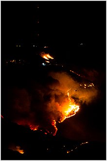
 The Maria Fire shortly before flight operations were called off due to a drone on October 31 | |
| Date(s) |
|
| Location | Santa Paula, Ventura County, California |
| Coordinates | 34°18′08″N 118°59′50″W / 34.302212°N 118.997115°W |
| Statistics[1] | |
| Burned area | 9,999 acres (4,046 ha) |
| Impacts | |
| Structures destroyed | 4 damaged |
| Ignition | |
| Cause | downed electric power line owned by California Resources Corporation during extreme wind conditions[2] |
| Map | |
The Maria Fire was a wildfire that burned the south of the community of Santa Paula in the area of Somis, California on the top of South Mountain in Ventura County. The fire ignited in the evening hours of Thursday, October 31, 2019 and consumed well over 4,000 acres (16 km2) within its first several hours of burning.[3] Despite the aggressive initial attack by first responders, the fire exploded rapidly due to a strong Santa Ana wind event that was occurring in the area during its ignition.[3]
- ^ "Maria Fire". CAL FIRE. Retrieved October 31, 2019.
- ^ Cite error: The named reference
KCLU finalwas invoked but never defined (see the help page). - ^ a b Staff, ABC7. "Massive brush fire erupts on top of South Mountain near Santa Paula". ABC 7 Eyewitness News. Retrieved 31 October 2019.
{{cite web}}: CS1 maint: numeric names: authors list (link)

