Marine Parade | |
|---|---|
| Other transcription(s) | |
| • Simp. Chinese | 马林百列 |
| • Trad. Chinese | 馬林百列 |
| • Pinyin | Mǎlín Bǎiliè |
| • Malay | Marine Parade |
| • Tamil | மரின் பரேட் |
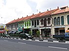
From top left to right: Panorama of East Coast Park, Marine Parade Promenade, Shophouses in Katong, Goodman Arts Centre, Katong Shopping Centre, Marine Parade Community Building, Marine Crescent Housing Estate, Tao Nan School | |
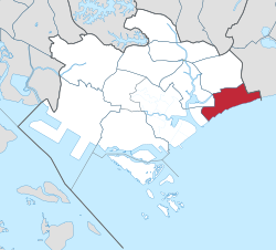
 Location in Central Region | |
| Coordinates: 1°18′11″N 103°54′28″E / 1.30306°N 103.90778°E | |
| Country | |
| Region | Central Region
|
| CDC | |
| Town council |
|
| Constituencies | |
| Government | |
| • Mayor | South East CDC
|
| • Members of Parliament | Marine Parade GRC
Mountbatten SMC |
| Area | |
| • Total | 6.12 km2 (2.36 sq mi) |
| Population | |
| • Total | 46,390 |
| • Density | 7,600/km2 (20,000/sq mi) |
| Demonym | Official
|
| Postal district | 15 |
| Dwelling units | 7,862 |
Marine Parade is a planning area and residential estate located on the eastern fringe of the Central Region of Singapore. Straddling the tip of the southeastern coast of Pulau Ujong, Marine Parade serves as a buffer between the Central and East regions of the country. Bordering it are the planning areas of Geylang to the north, Kallang to the northwest, Bedok to the northeast, Marina East to the southwest and the Singapore Straits to the south.
- ^ a b City Population – statistics, maps and charts | Marine Parade
- ^ HDB Key Statistics FY 2014/2015 Archived 4 March 2016 at the Wayback Machine
- ^ "Statistics Singapore - Geographic Distribution - 2018 Latest Data". Retrieved 11 February 2019.


