Marion County | |
|---|---|
 | |
 Location within the U.S. state of Indiana | |
 Indiana's location within the U.S. | |
| Coordinates: 39°47′N 86°08′W / 39.78°N 86.14°W | |
| Country | |
| State | |
| Founded | April 1, 1822 |
| Named for | Francis Marion |
| Seat | Indianapolis |
| Largest city | Indianapolis |
| Area | |
| • Total | 403.01 sq mi (1,043.8 km2) |
| • Land | 396.30 sq mi (1,026.4 km2) |
| • Water | 6.71 sq mi (17.4 km2) |
| Population (2020) | |
| • Total | 977,203 |
| • Estimate (2023) | 968,460 |
| • Density | 2,400/sq mi (940/km2) |
| Time zone | UTC−5 (Eastern) |
| • Summer (DST) | UTC−4 (EDT) |
| Congressional districts | 6th, 7th |
| Website | www |
| |
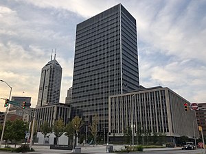
Marion County is located in the U.S. state of Indiana. The 2020 United States census reported a population of 977,203,[1] making it the 54th-most populous county in the U.S., the most populous county in the state, and the main population center of the 11-county Indianapolis–Carmel–Greenwood MSA in central Indiana. Indianapolis is the county seat, the state capital, and most populous city.[2] Marion County is consolidated with Indianapolis through an arrangement known as Unigov.
- ^ "Marion County QuickFacts". US Census Bureau. Retrieved January 31, 2022.
- ^ "Find a County". National Association of Counties. Retrieved June 7, 2011.