| Market Weighton Canal | |
|---|---|
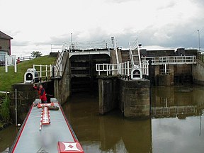
 Weighton Lock at the entrance to the canal | |
| Specifications | |
| Locks | 4 |
| Status | Part navigable |
| Navigation authority | Environment Agency |
| History | |
| Date of act | 1772 |
| Date completed | 1782 |
| Date closed | 1971 |
| Geography | |
| Start point | below Market Weighton |
| End point | Broomfleet |
| Connects to | Humber Estuary |
Market Weighton Canal | |||||||||||||||||||||||||||||||||||||||||||||||||||||||||||||||||||||||||||||||||||||||||||||||||||||||||||||||||||||||||||||||||||||||||||||||||||||||||||||||||
|---|---|---|---|---|---|---|---|---|---|---|---|---|---|---|---|---|---|---|---|---|---|---|---|---|---|---|---|---|---|---|---|---|---|---|---|---|---|---|---|---|---|---|---|---|---|---|---|---|---|---|---|---|---|---|---|---|---|---|---|---|---|---|---|---|---|---|---|---|---|---|---|---|---|---|---|---|---|---|---|---|---|---|---|---|---|---|---|---|---|---|---|---|---|---|---|---|---|---|---|---|---|---|---|---|---|---|---|---|---|---|---|---|---|---|---|---|---|---|---|---|---|---|---|---|---|---|---|---|---|---|---|---|---|---|---|---|---|---|---|---|---|---|---|---|---|---|---|---|---|---|---|---|---|---|---|---|---|---|---|---|---|
| |||||||||||||||||||||||||||||||||||||||||||||||||||||||||||||||||||||||||||||||||||||||||||||||||||||||||||||||||||||||||||||||||||||||||||||||||||||||||||||||||
The Market Weighton Canal ran 9.5 miles (15.3 km) from the Humber Estuary to its terminus near Market Weighton. It gained its act of Parliament in 1772 and opened in 1782. The 3.5 miles (5.6 km) closest to Market Weighton was abandoned in 1900 and the right of navigation through Weighton lock was lost in 1971. However, as of 2002 the lock was passable and the canal usable up to the junction with the River Foulness where silt has made it impassable.[1] Also there is no right of navigation under the M62 motorway bridge to the north of Newport.