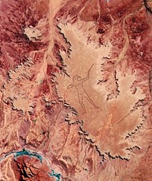

The Marree Man is a modern geoglyph created in 1998 in Outback South Australia. It depicts an Aboriginal man hunting with a boomerang or stick. It lies on a plateau at Finniss Springs, 60 km (37 mi) west of the township of Marree in central South Australia, approximately 12 km north-west of Callanna. It is just outside the 127,000-square-kilometre (49,000 sq mi)[1] Woomera Prohibited Area. The figure is 2.7 km (1.7 mi) tall with a perimeter of 28 km (17 mi), extending over an area of about 2.5 km2 (620 acres). Discovered fortuitously by a charter pilot in an overflight on 26 June 1998, it is one of the largest geoglyphs in the world, arguably second to the Sajama Lines). Its origin remains a mystery: no one claimed responsibility for its creation and no eye-witness has been found, notwithstanding the scale of the operation required to form the outline on the plateau floor. The description "Stuart's Giant" was used in anonymous faxes sent to media as press releases in July 1998, in a reference to the explorer John McDouall Stuart.
Shortly after its discovery, the South Australian government closed the site following legal action taken in late July by native title claimants, but flights over the site were not forbidden as native title fell under federal government jurisdiction.
- ^ "Woomera Prohibited Area" (PDF). Four Wheel Drive South Australia. 14 April 2002. Retrieved 5 November 2013.