| Maryborough Victoria | |||||||||
|---|---|---|---|---|---|---|---|---|---|
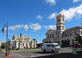
 McLandress Square, with the post office and court house | |||||||||
| Coordinates | 37°03′00″S 143°44′06″E / 37.05000°S 143.73500°E | ||||||||
| Population | 7,769 (2021 census)[1] | ||||||||
| Established | 1854 | ||||||||
| Postcode(s) | 3465 | ||||||||
| Elevation | 249 m (817 ft) | ||||||||
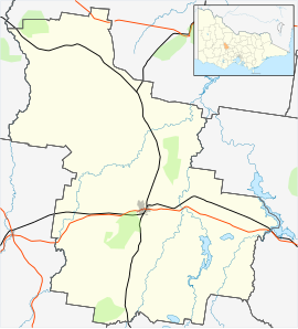
| Location |
| ||||||||
| LGA(s) | Shire of Central Goldfields | ||||||||
| State electorate(s) | Ripon | ||||||||
| Federal division(s) | Mallee | ||||||||
| |||||||||

Maryborough (/ˈmɛəribərə/)[2] is a town in Victoria, Australia, on the Pyrenees Highway, 58 kilometres (36 mi) north of Ballarat and 168 kilometres (104 mi) northwest of Melbourne, in the Shire of Central Goldfields. At the 2021 census, the urban centre had a population of 7,769,[1] while the larger Level 2 Statistical Area which includes the urban fringe, had a population of 8,160,[3] both an increase of more than 3% since 2016.
- ^ a b "2021 Maryborough (Vic.), Census All persons QuickStats | Australian Bureau of Statistics".
- ^ Macquarie Dictionary, Fourth Edition (2005). Melbourne, The Macquarie Library Pty Ltd. ISBN 1-876429-14-3
- ^ "2021 Maryborough (Vic.), Census All persons QuickStats | Australian Bureau of Statistics".
