Marysvale, Utah | |
|---|---|
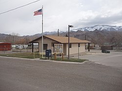
 Marysvale post office | |
 Location in Piute County and the state of Utah. | |
| Coordinates: 38°26′51″N 112°13′58″W / 38.44750°N 112.23278°W | |
| Country | United States |
| State | Utah |
| County | Piute |
| Settled | 1863 |
| Incorporated | 1913 |
| Area | |
| • Total | 17.99 sq mi (46.60 km2) |
| • Land | 17.98 sq mi (46.57 km2) |
| • Water | 0.01 sq mi (0.03 km2) |
| Elevation | 5,863 ft (1,787 m) |
| Population (2010) | |
| • Total | 408 |
| • Estimate (2019)[2] | 437 |
| • Density | 24.31/sq mi (9.38/km2) |
| Time zone | UTC-7 (Mountain (MST)) |
| • Summer (DST) | UTC-6 (MDT) |
| ZIP code | 84750 |
| Area code | 435 |
| FIPS code | 49-48610[3] |
| GNIS feature ID | 1443220[4] |
Marysvale is a town in Piute County, Utah, United States. The population was 408 at the 2010 census. Marysvale is a trail head for the Paiute ATV Trail.
- ^ "2019 U.S. Gazetteer Files". United States Census Bureau. Retrieved August 7, 2020.
- ^ Cite error: The named reference
USCensusEst2019CenPopScriptOnlyDirtyFixDoNotUsewas invoked but never defined (see the help page). - ^ "U.S. Census website". United States Census Bureau. Retrieved January 31, 2008.
- ^ "US Board on Geographic Names". United States Geological Survey. October 25, 2007. Retrieved January 31, 2008.