Mashteuiatsh | |
|---|---|
 | |
| Coordinates: 48°34′N 72°14′W / 48.567°N 72.233°W[1] | |
| Country | |
| Province | |
| Region | Saguenay–Lac-Saint-Jean |
| RCM | None |
| Formed | September 6, 1856 |
| Government | |
| • Chief | Gilbert Dominique |
| • Federal riding | Roberval—Lac-Saint-Jean |
| • Prov. riding | Roberval |
| Area | |
| • Total | 15.20 km2 (5.87 sq mi) |
| • Land | 14.43 km2 (5.57 sq mi) |
| Population (2021)[4] | |
| • Total | 2,010 |
| • Density | 139.3/km2 (361/sq mi) |
| • Change (2016–21) | |
| • Dwellings | 1,095 |
| Time zone | UTC−5 (EST) |
| • Summer (DST) | UTC−4 (EDT) |
| Postal Code | G0W 2H0 |
| Area code(s) | 418 and 581 |
| Website | www |
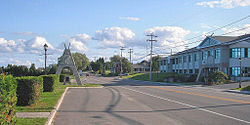
Mashteuiatsh is a First Nations reserve in the Saguenay–Lac-Saint-Jean region of Quebec, Canada, about 6 kilometres (3.7 mi) north from the centre of Roberval. It is the home to the Pekuakamiulnuatsh First Nation. It is located on a headland jutting out on the western shores of Lake Saint-Jean known as Pointe-Bleue, in the geographic township of Ouiatchouan, and belongs to the Montagnais du Lac St-Jean Innu band.[3] It is geographically within the Le Domaine-du-Roy Regional County Municipality but administratively not part of it.
Previously officially known as Ouiatchouan Reserve, it was renamed Mashteuiatsh in 1985, from Ka Mesta8iats, meaning "where there is a point" or "seeing one yet again at the point".[1]
Mashteuiatsh is serviced by a health centre, community radio station, arena, library, community and sports centre, social services centre, municipal water and sewer system, fire station, and an aboriginal police force.[3] The reserve is home to the Mashteuiatsh Amerindian Museum (Musée amérindien de Mashteuiatsh), which was founded in 1977 with a mission to preserve Innu cultural heritage.
- ^ a b "Mashteuiatsh (Réserve indienne)" (in French). Commission de toponymie du Québec. Retrieved 2010-12-02.
- ^ a b Ministère des Affaires municipales, des Régions et de l'Occupation du territoire - Répertoire des municipalités: Mashteuiatsh Archived 2014-09-15 at the Wayback Machine
- ^ a b c "Mashteuiatsh First Nation". Aboriginal Community profiles. Aboriginal Affairs and Northern Development Canada. Archived from the original on 2011-10-14. Retrieved 2010-12-02.
- ^ a b "Mashteuiatsh census profile". 2021 Census data. Statistics Canada. 9 February 2022. Retrieved 2022-03-21.
