| Matanzas Creek | |
|---|---|
 Matanzas Creek at Doyle Community Park, Santa Rosa, California | |
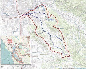
 Matanzas Creek watershed (Interactive map) | |
| Etymology | Spanish |
| Location | |
| Country | United States |
| State | California |
| Region | Sonoma County |
| City | Santa Rosa, California |
| Physical characteristics | |
| Source | north slope of Sonoma Mountain |
| • location | 3 mi (5 km) west of Glen Ellen, California |
| • coordinates | 38°21′23″N 122°34′49″W / 38.35639°N 122.58028°W[1] |
| • elevation | 1,980 ft (600 m) |
| Mouth | Santa Rosa Creek |
• location | downtown Santa Rosa |
• coordinates | 38°26′15″N 122°42′45″W / 38.43750°N 122.71250°W[1] |
• elevation | 151 ft (46 m)[1] |
| Basin features | |
| Tributaries | |
| • left | South Fork Matanzas Creek |
| • right | Spring Creek |
Matanzas Creek is an 11.4-mile-long (18.3 km)[2] year-round stream in Sonoma County, California, United States, a tributary of Santa Rosa Creek.
- ^ a b c U.S. Geological Survey Geographic Names Information System: Matanzas Creek
- ^ U.S. Geological Survey. National Hydrography Dataset high-resolution flowline data. The National Map Archived 2012-03-29 at the Wayback Machine, accessed March 9, 2011