| Mattawa River Petite Rivière | |
|---|---|
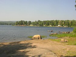
 Pimisi Bay on the Mattawa River | |
 Mattawa River basin map | |
| Etymology | Algonquin language |
| Location | |
| Country | Canada |
| Province | Ontario |
| District | Nipissing |
| Physical characteristics | |
| Source | Trout Lake |
| • location | North Bay, Ontario |
| • coordinates | 46°18′48″N 79°16′09″W / 46.31333°N 79.26917°W |
| • elevation | 198.5 m (651 ft) |
| Mouth | Ottawa River |
• location | Mattawa, Ontario |
• coordinates | 46°19′13″N 78°42′26″W / 46.32028°N 78.70722°W |
• elevation | 148 m (486 ft) |
| Length | 76 km (47 mi) |
| Basin size | 1,170 km2 (450 sq mi) |
| Basin features | |
| Progression | Ottawa River→ St. Lawrence River→ Gulf of St. Lawrence |
| River system | Ottawa River drainage basin |
| Tributaries | |
| • right | Kaibuskong River, Amable du Fond River |
The Mattawa River is a river in central Ontario, Canada. It flows east from Trout Lake east of North Bay and enters the Ottawa River at the town of Mattawa. Counting from the head of Trout Lake, it is 76 kilometres (47 mi) long. The river's name comes from the Algonquin word for "meeting of waterways".
Two provincial parks are located along it: the Mattawa River Provincial Park stretches along both sides of the river's banks for almost its full length; and Samuel de Champlain Provincial Park, located about 10 kilometres (6.2 mi) from the river's end.