Maumee, Ohio | |
|---|---|
 Maumee Historic District | |
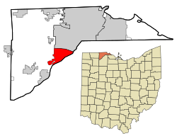
 Location in Lucas County and the state of Ohio. | |
| Coordinates: 41°34′25″N 83°38′45″W / 41.57361°N 83.64583°W | |
| Country | United States |
| State | Ohio |
| County | Lucas |
| Area | |
| • Total | 10.79 sq mi (27.93 km2) |
| • Land | 10.04 sq mi (26.02 km2) |
| • Water | 0.74 sq mi (1.92 km2) |
| Elevation | 633 ft ([2] m) |
| Population (2020) | |
| • Total | 13,896 |
| • Density | 1,383.37/sq mi (534.11/km2) |
| Time zone | UTC−5 (EST) |
| • Summer (DST) | UTC−4 (EDT) |
| ZIP code | 43537 |
| Area code | 419/567 |
| FIPS code | 39-48342[3] |
| GNIS feature ID | 1086527[2] |
| Website | www.maumee.org |
Maumee (/mɔːˈmiː/ maw-MEE) is a city in Lucas County, Ohio, United States. Located along the Maumee River, it is a suburb about 10 miles (16 km) southwest of Toledo. The population was 13,896 at the 2020 census. Maumee was declared an All-America City by the National Civic League in June 2006.
- ^ "ArcGIS REST Services Directory". United States Census Bureau. Retrieved September 20, 2022.
- ^ a b U.S. Geological Survey Geographic Names Information System: Maumee, Ohio
- ^ "U.S. Census website". United States Census Bureau. Retrieved January 31, 2008.
