| Maydena Tasmania | |||||||||
|---|---|---|---|---|---|---|---|---|---|
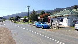
 Looking east on main road | |||||||||
| Coordinates | 42°45′19″S 146°37′36″E / 42.75528°S 146.62667°E | ||||||||
| Population | 198 (2021 census)[1] | ||||||||
| Postcode(s) | 7140 | ||||||||
| Elevation | 281 m (922 ft)[2] | ||||||||
| Location |
| ||||||||
| LGA(s) | Derwent Valley Council | ||||||||
| State electorate(s) | Lyons | ||||||||
| Federal division(s) | Lyons | ||||||||
| |||||||||
Maydena is a locality in Tasmania, Australia, alongside the River Tyenna.
Maydena is on the Gordon River Road, south west of New Norfolk, through the Bushy Park Hop Fields, turn left at Westerway, past Mount Field National Park and Russell Falls, through Tyenna and Fitzgerald townships and then up to Maydena itself. Gordon River Road continues to Lake Pedder, Lake Gordon and Strathgordon, in the Southwest National Park of Tasmania. Maydena was formerly called Junee and was a small settlement that provided access to Adamsfield Osmiridium mining in the early 1900s. In 1947-1950 Australian Newsprint Mills built 100 houses for the workers of the forestry operations of Australian Newsprint Mill to provide timber for the production of newsprint at their newsprint Mill in Boyer, Tasmania.
At the 1954 Census Maydena had a population of 518 with a further 60 at the Maydena Newsprint Camp. At the 2021 census, Maydena had a population of 198.
Maydena's state primary school and a community online centre have now been closed.[3]
- ^ Australian Bureau of Statistics (28 June 2022). "Maydena (State Suburb)". 2021 Census QuickStats. Retrieved 28 April 2023.
- ^ Bureau of Meteorology. Retrieved 10 November 2007
- ^ Maydena Community Online Center Archived 6 July 2011 at the Wayback Machine
