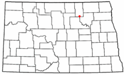
Maza, North Dakota | |
|---|---|
 Location of Maza, North Dakota | |
| Coordinates: 48°23′42″N 99°11′59″W / 48.39500°N 99.19972°W | |
| Country | |
| State | North Dakota |
| County | Towner |
| Area | |
| • Total | 9.1 sq mi (23.4 km2) |
| • Land | 8.2 sq mi (21.2 km2) |
| • Water | 0.9 sq mi (2.2 km2) |
| Elevation | 1,460 ft (450 m) |
| Population (2000) | |
| • Total | 5 |
| • Density | 0.6/sq mi (0.2/km2) |
| Time zone | UTC-6 (Central (CST)) |
| • Summer (DST) | UTC-5 (CDT) |
| ZIP code | 58324 |
| Area code | 701 |
| FIPS code | 38-38980[2] |
| GNIS feature ID | 1036156[1] |
Maza is a former city in Towner County, North Dakota, United States. The population was 5 at the 2000 census. Maza was founded in 1893. Maza was incorporated as a city until 2002, when the city was dissolved and governance reverted to the surrounding Maza Township.[3][4] Maza shares a zip code of 58324 with the city of Cando to the north.[5]
- ^ a b U.S. Geological Survey Geographic Names Information System: Maza, North Dakota
- ^ "U.S. Census website". United States Census Bureau. Retrieved January 31, 2008.
- ^ U.S. Census Bureau: Boundary Changes
- ^ 2002 Taxable Valuations Archived 2007-09-28 at the Wayback Machine, North Dakota League of Cities
- ^ U.S. Postal Service Zip Code Lookup