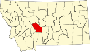
Meagher County | |
|---|---|
 | |
 Location within the U.S. state of Montana | |
 Montana's location within the U.S. | |
| Coordinates: 46°48′47″N 111°12′36″W / 46.813°N 111.21°W | |
| Country | |
| State | |
| Founded | November 16, 1867 |
| Named for | Thomas Francis Meagher |
| Seat | White Sulphur Springs |
| Largest city | White Sulphur Springs |
| Area | |
• Total | 2,395 sq mi (6,200 km2) |
| • Land | 2,392 sq mi (6,200 km2) |
| • Water | 2.8 sq mi (7 km2) 0.1% |
| Population (2020) | |
• Total | 1,927 |
• Estimate (2022) | 2,013 |
| • Density | 0.80/sq mi (0.31/km2) |
| Time zone | UTC−7 (Mountain) |
| • Summer (DST) | UTC−6 (MDT) |
| Congressional district | 2nd |
| Website | www |
| |
Meagher County (/ˈmɑːr/ MARR) is a county located in the U.S. state of Montana. As of the 2020 census, the population was 1,927.[1] Its county seat is White Sulphur Springs.[2]
According to the United States Census Bureau, the 2010 center of population of Montana is located in Meagher County at 46°47′N 111°18′W / 46.78°N 111.3°W[3]
- ^ "State & County QuickFacts". United States Census Bureau. Retrieved May 8, 2023.
- ^ "Find a County". National Association of Counties. Retrieved June 7, 2011.
- ^ "Centers of Population by State: 2010" (txt). United States Census Bureau. Retrieved March 29, 2014.