-
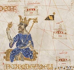 Mussa Melli and Timbuktu
 -
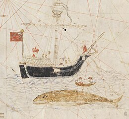 Whaling in the north Atlantic
 -
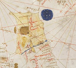 Scotland and northern England
Mecia de Viladestes, also known as Mecià or Macià de Viladestes was a 15th century Jewish cartographer, one of the Mallorcan school of cartography.[1] The name Mecia is a variant of Matias or Matthew. His birth name was Samuel Corchos.[2] In 1401, he was conveyed to Sicily under license from the governor of Mallorca, presumably one of the Jews forcibly converted to Christianity around this time.[3][4]

He is mostly known for his 1413 portolan chart which shows the N.E Atlantic Ocean, the Mediterranean Sea, the Black Sea, the Red Sea, and parts of the Caspian Sea, the Persian Gulf and the Baltic Sea. The map, which measures 1.21 X 0.87m, was discovered by Joaquín Lorenzo Villanueva in the archives of the Carthusian monastery of the Val de Cristo, near the town of Segorbe in Spain. It bears the inscription in gold letters MECIA DE VILA DESTIS ME FECIT IN ANO MCCCCXIII - Mecia de Viladestes made me in the year 1413.[5][3] A complete reproduction of the map was first published in 1896.[6] The map is now in the National Library of France.[7]
The map is notable as one of the first to show detail of Africa south of the Atlas Mountains. This includes factual material, such as Mali with Timbuktu and an image of its 14th Century King Mussa Melli; as well as conjectural material, such as Prester John, shown in Ethiopia.[2] The north Atlantic shows a whaling ship, and Great Britain is shown without the distortion or "turning" of Scotland that is found in later maps, after Ptolemy's Geography became available in Latin translation.[8] The border between England and Scotland is very stylized, with mountains and two castles (probably Carlisle and Edinburgh) shown at right angles to the border, and rivers running east and west from the mountains. This convention may have led to later portolan charts showing England and Scotland as separate islands.[9][10]
Details from the 1413 chart


- ^ Entralgo, Pedro Laín; Piñero, José M.López (1960). "The Spanish contribution to world science". Cahiers d'Histoire Mondiale. 6 (1): 948–968. ISSN 0022-5436.
- ^ a b Brunnlechner, Gerda (2018). "In Search of Prester John and the 'River of Gold'. Mecià de Viladestes' Map and Late Medieval Knowledge about Africa". Journal of Transcultural Medieval Studies. 5 (2): 261–294. doi:10.1515/JTMS-2018-0021. S2CID 186962200.
- ^ a b Hamy, Ernest Théodore (1902). "Mecia de Viladestes: cartographe juif majorcain du commencement du XVe siècle". Comptes rendus des séances de l'Académie des Inscriptions et Belles-Lettre (in French). 46th Year (1): 71–75.
- ^ The Jewish encyclopedia : a descriptive record of the history, religion, literature, and customs of the Jewish people from the earliest times to the present day. Volume 8. New York: Funk and Wagnalls. 1901. p. 398.
- ^ Villanueva, Joaquin Lorenzo (1806). Viage literario a las iglesias de España Volume 4 (in Spanish). Madrid: En la Imprenta Real. p. 25.
- ^ Marcel, Gabriel (17 February 1896). Choix de Cartes et de Mappemondes des XIVe et XVe siecles (in French). Portal Patrimonio Cultural de DefMinisterio de Defensa de España. Retrieved 25 November 2023.
{{cite book}}:|website=ignored (help) - ^ Mecia de Viladestes. "Carte marine de l'océan Atlantique Nord-Est, de la mer Méditerranée, de la mer Noire, de la mer Rouge, d'une partie de la mer Caspienne, du golfe Persique et de la mer Baltique". BnF Gallica. Retrieved 25 November 2023.
- ^ Jones, Barri; Keillar, Ian (1996). "Marinus, Ptolemy and the turning of Scotland". Britannia. 27: 43–49. doi:10.2307/527039. JSTOR 527039. S2CID 162963045.
- ^ Andrews, Michael C. (1927). "The boundary between Scotland and England in the portolan charts". Proceedings of the Society of Antiquaries of Scotland. 80: 36–66.
- ^ Steinberg, Philip E. (2005). "Insularity, sovereignty and statehood: The representation of islands on portolan charts and the construction of the territorial state". Geografiska Annaler: Series B, Human Geography. 87 (4): 253–265. doi:10.1111/j.0435-3684.2005.00197.x. S2CID 145072522.