Megargel, Texas | |
|---|---|
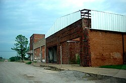
 A row of abandoned shops in Megargel, July 2009 | |
 Location of Megargel, Texas | |
 | |
| Coordinates: 33°27′13″N 98°55′47″W / 33.45361°N 98.92972°W | |
| Country | United States |
| State | Texas |
| County | Archer |
| Area | |
| • Total | 0.62 sq mi (1.60 km2) |
| • Land | 0.61 sq mi (1.58 km2) |
| • Water | 0.01 sq mi (0.02 km2) |
| Elevation | 1,270 ft (390 m) |
| Population (2020) | |
| • Total | 174 |
| • Density | 280/sq mi (110/km2) |
| Time zone | UTC-6 (Central (CST)) |
| • Summer (DST) | UTC-5 (CDT) |
| ZIP code | 76370 |
| Area code | 940 |
| FIPS code | 48-47460[3] |
| GNIS feature ID | 2412980[2] |
Megargel (/ˈmiːɡɑːrɡəl/ MEE-gar-gəl) is a town in Archer County, Texas, United States. It is part of the Wichita Falls, Texas metropolitan statistical area. Its population was 174 at the 2020 census. The town is named for Roy C. Megargel, the president of the railroad that developed the town.
- ^ "2019 U.S. Gazetteer Files". United States Census Bureau. Retrieved August 7, 2020.
- ^ a b U.S. Geological Survey Geographic Names Information System: Megargel, Texas
- ^ "U.S. Census website". United States Census Bureau. Retrieved January 31, 2008.