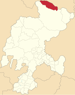
Melchor Ocampo | |
|---|---|
 Location of Melchor Ocampo in Zacatecas | |
| Coordinates: 24°49′52″N 101°38′33″W / 24.83111°N 101.64250°W[1] | |
| Country | |
| State | |
| Established | 19 August 1916 |
| Seat | Melchor Ocampo |
| Government | |
| • Municipal president | Rodolfo Cisneros Gallegos |
| Area | |
| • Total | 1,881.4 km2 (726.4 sq mi) |
| Elevation [1] (of seat) | 2,030 m (6,660 ft) |
| Population (2020 Census)[2] | |
| • Total | 2,736 |
| • Density | 1.5/km2 (3.8/sq mi) |
| • Seat | 698 |
| Time zone | UTC-6 (Central) |
| • Summer (DST) | UTC-5 (Central) |
| Postal codes | 98220–98229[3] |
| Area code | 842 |
Melchor Ocampo is a municipality in the Mexican state of Zacatecas, located approximately 250 kilometres (160 mi) north of Zacatecas City, the state capital. It is named after Melchor Ocampo.
- ^ a b "Sistema Nacional de Información Municipal" (in Spanish). SEGOB. 2010. Retrieved 2 January 2022.
- ^ a b Cite error: The named reference
panoramawas invoked but never defined (see the help page). - ^ "Consulta de Códigos Postales". Catálogo Nacional de Códigos Postales. Mexican Postal Service. 1 January 2022. Retrieved 2 January 2022.