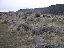
Melon gravel are a geological deposit of mostly basalt boulders that were formed by the Lake Bonneville flood and deposited along the Snake River Plain in the western United States around 15,000 years ago.[1] Melon gravel range in size from coarse sand to well over fifteen feet (4.6 m) in diameter, and generally appear rounded.[2] Melon gravel were formed by the Bonneville Flood's intense erosion of the surrounding basalt flows of the area. This process also created several bars of melon gravel that, at their largest, can be one mile (1.6 km) long, 1.5 miles (2.4 km) wide, and 150 feet (46 m) deep.[3]
Melon gravel are considered to be "the most easily recognized evidence of the catastrophic magnitude of the [Bonneville] flood".[4] Melon gravel were named after road signs were put up advertising "petrified watermelons", with one sign urging people to "take one home to your mother-in-law!"[5]
- ^ "The Lake Bonneville Flood". Digital Atlas. The Digital Atlas of Idaho. Retrieved 8 July 2022.
- ^ Malde, Harold; Powers, Howard (1962). "Upper Cenozoic Stratigraphy of Western Snake River Plain, Idaho". Geological Society of America Bulletin. 73 (10): 1197–1220. doi:10.1130/0016-7606(1962)73[1197:UCSOWS]2.0.CO;2. Retrieved 8 July 2022.
- ^ "Geologic Unit: Melon". Geolex. USGS. Retrieved 8 July 2022.
- ^ Malde, Harold (1968). "The Catastrophic Late Pleistocene Bonneville Flood in the Snake River Plain, Idaho" (PDF). Geological Survey Professional Paper 596: 13. Retrieved 8 July 2022.
- ^ Meldahl, Keith (16 October 2011). Rough-Hewn Land: A Geologic Journey from California to the Rocky Mountains. University of California Press. p. 132. ISBN 978-0520275775. Retrieved 8 July 2022.