| Menabe Antimena | |
|---|---|
IUCN category V (protected landscape/seascape)[1] | |
 | |
| Location | Menabe, Madagascar |
| Nearest city | Morondava |
| Coordinates | 19°56′37″S 44°40′46″E / 19.94361°S 44.67944°E |
| Area | 2,094.61 km2 (808.73 sq mi) |
| Designation | Paysage Harmonieux Protégé (harmonious protected landscape) |
| Designated | July 2007 |
| Official name | Zones humides de Bedo |
| Designated | 12 May 2007 |
| Reference no. | 1686[2] |
| Official name | Mangroves de Tsiribihina |
| Designated | 22 May 2017 |
| Reference no. | 2302[3] |
Menabe Antimena is a protected area in Menabe region of western Madagascar. It belongs to the municipalities of Tsimafana, Beroboka, Bemanonga, Belon'i Tsiribihina, and Tsaraotana.[4]
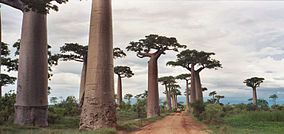
Menabe Antimena is on the west coast of Madagascar, south of the Mania River.[1] It covers an area of dry forest, succulent woodland, mangroves, and secondary grassland and scrub. It includes the northern portion of the Kirindy Forest[5] and the Avenue of the Baobabs.
Large areas have been illegally logged, burned, and converted to maize fields, which threatens the area's wildlife, including the critically endangered Madame Berthe's mouse lemur (Microcebus berthae), the smallest primate in the world.[5]
- ^ a b Protected Area Profile for Menabe Antimena from the World Database on Protected Areas. Accessed 9 September 2022.
- ^ "Zones humides de Bedo". Ramsar Sites Information Service. Retrieved 9 September 2022.
- ^ "Mangroves de Tsiribihina". Ramsar Sites Information Service. Retrieved 9 September 2022.
- ^ Ramsar.org
- ^ a b Ratsimbazafy, Rondro (6 September 2019). "Madagascar forest destruction wiping out humans' tiniest relative". Reuters. Retrieved 9 September 2022.
