Mendocino County, California | |
|---|---|
| County of Mendocino | |
|
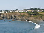
Images, from top down, left to right: The community of Mendocino, the historic Grace Hudson Sun House, Point Arena Lighthouse, the Chandelier Tree, the "Skunk Train", a beach in MacKerricher State Park | |
| Nickname: "Mendo" | |
 Interactive map of Mendocino County with markers for each of its four incorporated cities: Ukiah (red), Fort Bragg (purple), Point Arena (blue), and Willits (yellow) | |
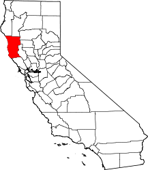
 Mendocino County's location within California | |
| Coordinates (Geographic center of Mendocino County): 39°28′09″N 123°23′39″W / 39.4692°N 123.3942°W | |
| Country | United States |
| State | California |
| Region | California North Coast |
| Incorporated | February 18, 1850[1] |
| Named for | Antonio de Mendoza, Viceroy of New Spain, 1535–42 |
| County seat | Ukiah |
| Largest city | Ukiah |
| Government | |
| • Type | Council–CEO |
| • Body | Mendocino County Board of Supervisors |
| • Chair | Glenn McGourty |
| • Vice Chair | Maureen Mulheren |
| • Board of Supervisors[2] | Supervisors
|
| • Chief executive officer | Darcie Antle |
| Area | |
| • Total | 3,878 sq mi (10,040 km2) |
| • Land | 3,506 sq mi (9,080 km2) |
| • Water | 372 sq mi (960 km2) |
| Highest elevation | 6,958 ft (2,121 m) |
| Population | |
| • Total | 91,601 |
| • Density | 26/sq mi (10/km2) |
| GDP | |
| • Total | $4.277 billion (2022) |
| Time zone | UTC−8 (Pacific Time Zone) |
| • Summer (DST) | UTC−7 (Pacific Daylight Time) |
| Area code | 707 |
| Congressional district | 2nd |
| Website | www |
Mendocino County (/ˌmɛndəˈsiːnoʊ/ ; Mendocino, Spanish for "of Mendoza")[6] is a county located on the North Coast of the U.S. state of California. As of the 2020 census, the population was 91,601.[7] The county seat is Ukiah.[8]
Mendocino County consists wholly of the Ukiah, California Micropolitan Statistical Area (μSA) for the purposes of the U.S. Census Bureau. It is located approximately equidistant from the San Francisco Bay Area and California/Oregon border, separated from the Sacramento Valley to the east by the California Coast Ranges. While smaller areas of redwood forest are found further south, it is the southernmost California county to be included in the World Wildlife Fund's Pacific temperate rainforests ecoregion, the largest temperate rainforest ecoregion on Earth.[9]
The county is noted for its distinctive Pacific Ocean coastline, its location along California's "Lost Coast", Redwood forests, wine production, microbrews, and liberal views about the use of cannabis and support for its legalization. In 2009, it was estimated that roughly one-third of the economy was based on the cultivation of marijuana.[10]
The notable historic and recreational attraction of the "Skunk Train" previously connected Fort Bragg with Willits in Mendocino County via a steam-locomotive, before a tunnel collapse in 2013.
Mendocino is one of three Northern California counties to make up the "Emerald Triangle", along with Humboldt and Trinity counties.
- ^ "Chronology". California State Association of Counties. Archived from the original on February 6, 2015. Retrieved February 6, 2015.
- ^ "Board of Supervisors | Mendocino County, CA".
- ^ "Anthony Peak". Peakbagger.com. Archived from the original on May 2, 2015. Retrieved March 26, 2015.
- ^ "QuickFacts - Mendocino County, California". United States Census Bureau.
- ^ "Gross Domestic Product: All Industries in Mendocino County, CA". Federal Reserve Economic Data. Federal Reserve Bank of St. Louis.
- ^ Sanchez, Nellie Van de Grift (August 11, 1914). Spanish and Indian Place Names of California: Their Meaning and Their Romance. A.M. Robertson. ISBN 9781404750845 – via Google Books.
- ^ "Mendocino County, California". United States Census Bureau. Retrieved January 30, 2022.
- ^ "NACo County Explorer – Mendocino County, California". National Association of Counties. Retrieved August 22, 2019.
- ^ "Northern California coastal forests | Ecoregions". World Wildlife Fund. Archived from the original on August 22, 2019. Retrieved August 22, 2019.
- ^ Regan, Trish (January 23, 2009). Marijuana Inc., Inside America's Pot Industry (televised documentary). Mendocino County, California, USA: CNBC, Incorporated. Retrieved March 15, 2009.


