Meremere | |
|---|---|
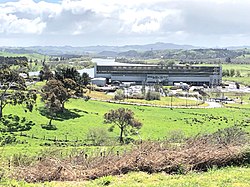
 The decommissioned Meremere power station | |
 | |
| Coordinates: 37°19′S 175°04′E / 37.317°S 175.067°E | |
| Country | New Zealand |
| Region | Waikato |
| District | Waikato District |
| Ward | Whangamarino Ward |
| Electorates | |
| Government | |
| • Territorial Authority | Waikato District Council |
| • Regional council | Waikato Regional Council |
| Area | |
• Total | 1.59 km2 (0.61 sq mi) |
| Population (June 2024)[2] | |
• Total | 660 |
| • Density | 420/km2 (1,100/sq mi) |
Meremere is a small town in the northern Waikato region in the North Island of New Zealand. It is located on the east bank of the Waikato River, 50 kilometres north of Hamilton and 63 km south of Auckland.
Meremere was the site of fighting in 1863 during the New Zealand Wars, at which time the settlement (then known as Mere Mere) was the site of a Māori defensive outpost.
For a number of years a coal-fired power station operated in Meremere, and much of the workforce lived in the town. The station was the first government-built large scale thermal power station, opening in 1958 and was a notable landmark for travellers along State Highway 1, which runs past the town. An aerial ropeway carried buckets of coal to the station from the Maramarua coal mine. The station closed in 1991 and there were plans during the 1990s to convert the station into a waste to energy plant, using waste from Auckland. These plans, known as the Olivine project, did not eventuate. The site was used as a recycling centre from 2007 to at least 2017.[3][4]
- ^ Cite error: The named reference
Areawas invoked but never defined (see the help page). - ^ "Aotearoa Data Explorer". Statistics New Zealand. Retrieved 26 October 2024.
- ^ KHL Group
- ^ "Meremere land primed for development". The New Zealand Herald. 3 December 2016.