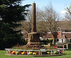
| Meriden | |
|---|---|
 The traditional centre of England | |
Location within the West Midlands | |
| Population | 2,719 (2011.Ward)[1] |
| OS grid reference | SP240824 |
| Civil parish |
|
| Metropolitan borough | |
| Shire county | |
| Metropolitan county | |
| Region | |
| Country | England |
| Sovereign state | United Kingdom |
| Post town | COVENTRY |
| Postcode district | CV7 |
| Dialling code | 01676 |
| Police | West Midlands |
| Fire | West Midlands |
| Ambulance | West Midlands |
| UK Parliament | |
Meriden is a village and civil parish in the Metropolitan Borough of Solihull, West Midlands, England. Historically, it is part of Warwickshire and lies between the cities of Birmingham and Coventry. It is located close to the North Warwickshire district border within a green belt of the countryside known as the Meriden Gap and is in the ecclesiastical parish of the Diocese of Coventry.
The village is 7.5 miles (12 kilometres) east-northeast of Solihull, 7 miles (11 kilometres) west-northwest of Coventry and 12 miles (19 kilometres) east-southeast of Birmingham city centre. It was known as "Alspath" in the Domesday Book. The village gives its name to the Meriden parliamentary constituency, which was created in 1955 and covers the Meriden Gap. In the 2011 Census, the population of the Meriden parish was 2,719.[2] The population is estimated to have risen to 3,096 by 2017.[2]
- ^ "Civil Parish 2011". Retrieved 16 December 2015.
- ^ a b "United Kingdom: West Midlands". CityPopulation.de. Retrieved 12 August 2019.
