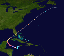
 Hurricane Wilma track map | |
| Meteorological history | |
|---|---|
| Formed | October 15, 2005 |
| Dissipated | October 26, 2005 |
| Category 5 major hurricane | |
| 1-minute sustained (SSHWS/NWS) | |
| Highest winds | 185 mph (295 km/h) |
| Lowest pressure | 882 mbar (hPa); 26.05 inHg (Record low in Atlantic) |
| Overall effects | |
| Areas affected | Hispaniola, Jamaica, Cuba, Cayman Islands, Central America, Southeast Mexico, East Coast of the United States (mainly in South Florida), Bahamas, Atlantic Canada, Europe |
Part of the 2005 Atlantic hurricane season | |
| History
Effects Other wikis | |
Hurricane Wilma was the most intense tropical cyclone in the Atlantic basin on record in terms of minimum barometric pressure, with an atmospheric pressure of 882 millibars (26.0 inHg). Wilma's destructive journey began in the second week of October 2005. A large area of disturbed weather developed across much of the Caribbean and gradually organized to the southeast of Jamaica. By late on October 15, the system was sufficiently organized for the National Hurricane Center to designate it as Tropical Depression Twenty-Four.
The depression drifted southwestward, and under favorable conditions, it strengthened into Tropical Storm Wilma on October 17. Initially, development was slow due to its large size, though convection steadily organized. From October 18, and through the following day, Wilma underwent explosive deepening over the open waters of the Caribbean; in a 30-hour period, the system's central atmospheric pressure dropped from 982 millibars (29.0 inHg) to the record-low value of 882 millibars (26.0 inHg), while the winds increased to 185 mph (298 km/h). At its peak intensity, the eye of Wilma was about 2.3 miles (3.7 km) in diameter, the smallest known eye in an Atlantic hurricane. After the inner eye dissipated due to an eyewall replacement cycle, Hurricane Wilma weakened to a Category 4 hurricane, and on October 21, it made landfall on Cozumel and on the Mexican mainland with winds of about 150 mph (240 km/h).
Wilma weakened over the Yucatán Peninsula, and reached the southern Gulf of Mexico before accelerating northeastward. Despite increasing amounts of vertical wind shear, the hurricane re-strengthened to hit Cape Romano, Florida, as a major hurricane. Wilma weakened as it quickly crossed the state, and entered the Atlantic Ocean near Jupiter, Florida. The hurricane again re-intensified before cold air and wind shear penetrated the inner core of convection. By October 26, it transitioned into an extratropical cyclone, and the next day, the remnants of Wilma were absorbed by another extratropical storm over Atlantic Canada.