| Mid Murray Council South Australia | |||||||||||||||
|---|---|---|---|---|---|---|---|---|---|---|---|---|---|---|---|
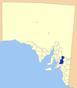
 Location of the Mid Murray Council in SA | |||||||||||||||
| Coordinates | 34°36′46″S 139°33′09″E / 34.6129°S 139.5525°E | ||||||||||||||
| Established | 1997 | ||||||||||||||
| Area | 7,957 km2 (3,072.2 sq mi) | ||||||||||||||
| Mayor | Simone Bailey[1] | ||||||||||||||
| Council seat | Mannum | ||||||||||||||
| Region | Murray and Mallee[2] | ||||||||||||||
| State electorate(s) | Chaffey, Schubert, Hammond, Stuart | ||||||||||||||
| Federal division(s) | Barker | ||||||||||||||
 | |||||||||||||||
| Website | Mid Murray Council | ||||||||||||||
| |||||||||||||||
The Mid Murray Council is a local government area in South Australia in the Murray and Mallee region of South Australia.[3] The council spans the area from the Riverland through the Murraylands to the eastern slopes of the Mount Lofty Ranges. It includes 220 km of the Murray River. The council seat is at Mannum; it also maintains secondary offices at Cambrai and Morgan.[4]
It was formed on 1 July 1997 from the amalgamation of the District Council of Mannum, the District Council of Morgan, the District Council of Ridley-Truro and part of the District Council of Mount Pleasant.[5][6][7]
- ^ "Elected Members". Mid Murray Council. Retrieved 31 March 2016.
- ^ "Murray and Mallee SA Government region" (PDF). The Government of South Australia. Retrieved 10 October 2014.
- ^ "Location SA Map Viewer". Government of South Australia. Retrieved 16 February 2016.
- ^ "Contact Us". Mid Murray Council. Retrieved 31 March 2016.
- ^ "Council Information". Mid-Murray Council. Retrieved 31 March 2016.
- ^ "Thursday, 13 February, 1997" (PDF). The Government Gazette of South Australia. Government of South Australia. Retrieved 2 December 2016.
- ^ "Thursday, 27 March 1997" (PDF). The Government Gazette of South Australia. Government of South Australia. Retrieved 2 December 2016.