| Middle Fork Eel River | |
|---|---|
 Middle Fork Eel River near Round Valley, low water, 2008 | |
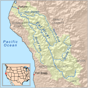
 Map of the Eel River drainage basin, including the Middle Fork Eel River | |
| Native name | Ba-ka-wha[1] |
| Location | |
| Country | United States |
| State | California |
| Region | Trinity County, Mendocino County |
| Physical characteristics | |
| Source | Near Wrights Ridge |
| • location | Yolla Bolly Mountains, Trinity County |
| • coordinates | 40°04′52″N 122°58′57″W / 40.08111°N 122.98250°W[1] |
| • elevation | 6,398 ft (1,950 m) |
| Mouth | Eel River |
• location | Dos Rios, Mendocino County |
• coordinates | 39°42′50″N 123°21′10″W / 39.71389°N 123.35278°W[1] |
• elevation | 863 ft (263 m)[1] |
| Length | 69.8 mi (112.3 km), Northeast-southwest |
| Basin size | 745 sq mi (1,930 km2)[2] |
| Discharge | |
| • location | Dos Rios, California[3] |
| • average | 1,472 cu ft/s (41.7 m3/s)[4] |
| • minimum | 0.39 cu ft/s (0.011 m3/s) |
| • maximum | 135,000 cu ft/s (3,800 m3/s) |
| Basin features | |
| River system | Eel River |
| Tributaries | |
| • left | Black Butte River |
| Designated | January 19, 1981 |
The Middle Fork Eel River is a major tributary of the Eel River of northwestern California in the United States.[1] It drains a rugged and sparsely populated region of the Yolla Bolly Mountains, part of the California Coast Range, in Trinity and Mendocino Counties. Its watershed comprises roughly 745 square miles (1,930 km2) of land, or 20% of the entire Eel River basin. The river provides groundwater recharge and is used for recreation and for industrial, agricultural and municipal water supply by residents.[5]
- ^ a b c d e "Middle Fork Eel River". Geographic Names Information System. United States Geological Survey, United States Department of the Interior. 1981-01-19. Retrieved 2010-06-17.
- ^ "USGS Gage #11478900 on the Middle Fork Eel River near Dos Rios". National Water Information System. 1966-present. U.S. Geological Survey. Retrieved 2010-06-17.
{{cite web}}: CS1 maint: others (link) - ^ "Water-Data Report 2009 for USGS Gage #11473900 on the Middle Fork Eel River near Dos Rios" (PDF). Water Resources of the United States. U.S. Geological Survey. 2009. Retrieved 2010-06-17.
- ^ "Water-Data Report 2009 for USGS Gage #11473900 on the Middle Fork Eel River near Dos Rios" (PDF). Water Resources of the United States. U.S. Geological Survey. 2009. Retrieved 2010-06-17.
- ^ State of California Water Quality Control Plan North Coastal Basin 1B July 1975 p.13