Midori
緑区 | |
|---|---|
| Midori Ward | |
 Arimatsu Historic Townscape on the Tokaido road in Midori-ku | |
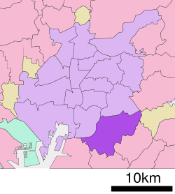
 Location of Midori-ku in Nagoya | |
| Coordinates: 35°04′15″N 136°57′08″E / 35.07083°N 136.95222°E | |
| Country | Japan |
| Region | Tōkai region Chūbu region |
| Prefecture | Aichi |
| Area | |
| • Total | 37.91 km2 (14.64 sq mi) |
| Population (October 1, 2019) | |
| • Total | 247,475 |
| • Density | 6,500/km2 (17,000/sq mi) |
| Time zone | UTC+9 (Japan Standard Time) |
| - Tree | Maple[1] |
| - Flower | Gymnaster savatieri |
| Phone number | 052-621-2111 |
| Address | 2-15 Aoyama, Midori-ku, Nagoya-shi, Aichi-ken 458-8585 |
| Website | www |
Midori-ku (緑区, Midori-ku) is one of the 16 wards of the city of Nagoya in Aichi Prefecture, Japan. As of 1 October 2019, the ward had an estimated population of 247,475 and a population density of 6,528 persons per km2. The total area was 37.91 km2. It is the largest of the wards of Nagoya in terms of population.

