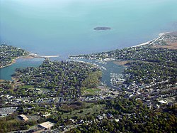
Milford, Connecticut | |
|---|---|
| City of Milford | |
 Aerial view of Milford city center and harbor | |
| Etymology: Ford by a mill | |
| Nickname: Sleepy Hollow[1] | |
| Motto: A Large City with a Big Heart! | |
| Coordinates: 41°13′27″N 73°03′35″W / 41.22417°N 73.05972°W | |
| Country | |
| U.S. state | |
| County | New Haven |
| Region | South Central CT |
| Settled | 1639 |
| Incorporated (city) | 1959 |
| Named for | Milford, Surrey |
| Government | |
| • Type | Mayor–Board of Aldermen |
| • Mayor | Tony Giannattasio (R) |
| Area | |
| • Total | 25.13 sq mi (65.09 km2) |
| • Land | 21.91 sq mi (56.73 km2) |
| • Water | 3.23 sq mi (8.35 km2) |
| Population | |
| • Total | 50,558 |
| • Density | 2,308/sq mi (891.2/km2) |
| United States Census 2010, United States Census Bureau | |
| Time zone | UTC−5 (Eastern) |
| • Summer (DST) | UTC−4 (Eastern) |
| ZIP Codes | 06460, 06461 |
| Area code(s) | 203/475 |
| FIPS code | 09-47515 |
| GNIS feature ID | 0208882 |
| Major highways | |
| Commuter Rail | |
| Website | www |
Milford is a coastal city in New Haven County, Connecticut, United States, between New Haven and Bridgeport. The population was 50,558 at the 2020 United States Census.[5] The city includes the village of Devon and the borough of Woodmont. Milford is part of the South Central Connecticut Planning Region and New York metropolitan area.
- ^ "Connecticut's Sleepy Hollow". ConnecticutHistory.org. ConnecticutHumanities. April 18, 2013. Retrieved June 14, 2017.
- ^ "2019 U.S. Gazetteer Files". United States Census Bureau. Retrieved July 2, 2020.
- ^ "CT - Milford city (balance)". United States Census 2010. US Census Bureau. Retrieved June 16, 2017.
- ^ "QuickFacts". US Census Bureau. U.S. Department of Commerce. Retrieved June 17, 2017.
- ^ "Census - Geography Profile: Milford city (balance), Connecticut". Retrieved December 17, 2021.


