Mingala Taungnyunt Township
မင်္ဂလာတောင်ညွန့် မြို့နယ် | |
|---|---|
Township of Yangon | |
| Mingala Taungnyunt Township | |
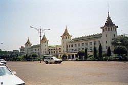
 Yangon Central Railway Station | |
| Coordinates: 16°47′0″N 96°10′0″E / 16.78333°N 96.16667°E | |
| Country | Myanmar |
| Division | Yangon |
| City | Yangon |
| Township | Mingala Taungnyunt |
| Area | |
| • Total | 5.06 km2 (1.955 sq mi) |
| Population (2000) | |
| • Total | 98,000 |
| • Density | 19,000/km2 (50,000/sq mi) |
| Time zone | UTC+6:30 (MST) |
| Postal codes | 11221, 11222 |
| Area code(s) | 1, (80, 99: mobile) |
| YCDC[1] | |
Mingala Taungnyunt Township (Burmese: မင်္ဂလာတောင်ညွန့် မြို့နယ် [mɪ̀ɰ̃ɡəlà tàʊɰ̃ ɲʊ̰ɰ̃ mjo̰nɛ̀]; also spelled Mingalar Taung Nyunt) is a township of Yangon, Myanmar. Located in the east-central part of the city, the township consists of 20 wards, and shares borders with Dagon Township in the west, Bahan township in the north, Botataung Township in the south, Kyauktada Township in the southwest, and the Pazundaung Creek and Dawbon Township in the east.
With nearly 100,000 residents, it is one of the most populous townships in the city. Mingala Taungnyunt has 22 primary schools, two middle schools and six high schools.[1]
- ^ a b "Mingala Taungnyunt Township". Yangon City Development Committee. Archived from the original on 2 October 2011. Retrieved 2009-01-25.
