Mira Loma | |
|---|---|
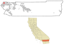
 Location in Riverside County and the state of California | |
| Coordinates: 33°59′05″N 117°30′55″W / 33.98472°N 117.51528°W | |
| Country | |
| State | |
| County | Riverside |
| Incorporated into Jurupa Valley | July 1, 2011 |
| Area | |
• Total | 8.149 sq mi (21.107 km2) |
| • Land | 7.997 sq mi (20.712 km2) |
| • Water | 0.152 sq mi (0.395 km2) 1.87% |
| Elevation | 722 ft (220 m) |
| Population (2010) | |
• Total | 21,930 |
| • Density | 2,700/sq mi (1,000/km2) |
| Time zone | UTC-8 (PST) |
| • Summer (DST) | UTC-7 (PDT) |
| ZIP code | 91752 |
| Area code | 951 |
| FIPS code | 06-47976 |
| GNIS feature ID | 1656568 |
Mira Loma (Spanish for "Look Hill"), now officially a neighborhood of Jurupa Valley, was a former census-designated place (CDP) in Riverside County, California, United States. Its population was 21,930 in the 2010 census, up from 17,617 in the 2000 census.
Mira Loma was known as Wineville prior to 1930. The name was changed that year to help disassociate the community from the Wineville Chicken Coop murders.
