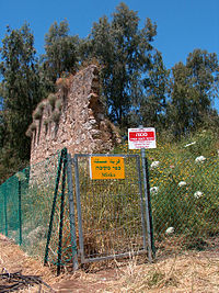
Miska
مسكة | |
|---|---|
Village | |
 Remains of the village mosque, 2007 | |
| Etymology: The water-hole[1] | |
A series of historical maps of the area around Miska, Tulkarm (click the buttons) | |
Location within Mandatory Palestine | |
| Coordinates: 32°13′04″N 34°55′29″E / 32.21778°N 34.92472°E | |
| Palestine grid | 143/180 |
| Geopolitical entity | Mandatory Palestine |
| Subdistrict | Tulkarm |
| Date of depopulation | 15 April 1948[4][5] |
| Area | |
| • Total | 8,076 dunams (8.076 km2 or 3.118 sq mi) |
| Population (1948) | |
| • Total | 880[2][3] |
| Cause(s) of depopulation | Expulsion by Yishuv forces |
| Current Localities | Sde Warburg, Mishmeret[6] |
Miska was a Palestinian village, located fifteen kilometers southwest of Tulkarm, depopulated in 1948.
- ^ Palmer, 1881, p. 175
- ^ Department of Statistics, 1945, p. 21
- ^ Government of Palestine, Department of Statistics. Village Statistics, April, 1945. Quoted in Hadawi, 1970, p. 76
- ^ Pappe, 1999, pp. 204, 209
- ^ Morris, 2004, p. xviii, village #191. Also gives cause of depopulation
- ^ Khalidi, 1992, p. 558


