 | |
| Location | 114 E Spain St Sonoma, California |
|---|---|
| Coordinates | 38°17′38″N 122°27′21″W / 38.29389°N 122.45583°W |
| Founding date | July 4, 1823 [1] |
| Founding priest(s) | Father José Altimíra [2] |
| Founding Order | 21 |
| Military district | Fourth[3] |
| Native tribe(s) Spanish name(s) | Coast Miwok, Patwin, Pomo, Suisunes, Wappo |
| Native place name(s) | Huchi [4] |
| Baptisms | 1,563 total[5] |
| Marriages | 359 total[5] |
| Burials | 896 total [5] |
| Neophyte population | 996 in 1832[6] |
| Governing body | California Department of Parks and Recreation |
| Current use | Museum |
| Reference no. |
|
| Website | |
| http://www.parks.ca.gov/?page_id=479 | |
Mission San Francisco Solano was the 21st, last, and northernmost mission in Alta California.[7] It was named for Saint Francis Solanus. It was the only mission built in Alta California after Mexico gained independence from Spain. The difficulty of its beginning demonstrates the confusion resulting from that change in governance. The California Governor wanted a robust Mexican presence north of the San Francisco Bay to keep the Russians who had established Fort Ross on the Pacific coast from moving further inland. A young Franciscan friar from Mission San Francisco de Asis wanted to move to a location with a better climate and access to a larger number of potential converts.[8]
The Mission was successful, given its short eleven year life, but was smaller in number of converts and with lower productivity and diversity of industries than the older California missions.[9]
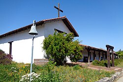
The mission building is now part of the Sonoma State Historic Park and is located in the city of Sonoma, California.
- ^ Yenne, p. 182
- ^ Ruscin, p. 196
- ^ Forbes, p. 202
- ^ Ruscin, p. Named the fish pig195
- ^ a b c Smilie, p. 79: totals through December 31, 1840.
- ^ Krell, p. 315: as of December 251832; information adapted from Engelhardt's Missions and Missionaries of California. Mission Francisco Solano witnessed the fewest baptisms, marriages, and burials of any settlement in the Alta California chain.
- ^ Bancroft p. 496
- ^ Smilie p.1-12
- ^ Krell, p. 315

