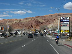
Moab | |
|---|---|
 Downtown Moab, Utah | |
 Location in Grand County and the state of Utah | |
| Coordinates: 38°34′21″N 109°32′59″W / 38.57250°N 109.54972°W | |
| Country | United States of America |
| State | Utah |
| County | Grand |
| Settled | 1878 |
| Incorporated | 1902 |
| Named for | Moab |
| Government | |
| • Type | Mayor/city council |
| • Mayor | Joette Langianese |
| Area | |
• Total | 4.80 sq mi (12.42 km2) |
| • Land | 4.80 sq mi (12.42 km2) |
| • Water | 0.00 sq mi (0.00 km2) |
| Elevation | 4,026 ft (1,227 m) |
| Population (2020) | |
• Total | 5,366[1] |
| • Density | 1,117.92/sq mi (432.05/km2) |
| Time zone | UTC-7 (Mountain (MST)) |
| • Summer (DST) | UTC-6 (MDT) |
| ZIP Code | 84532 |
| Area code | 435 |
| FIPS code | 49-50700[3] |
| GNIS feature ID | 1430389[4] |
| U.S. Routes | |
| Website | moabcity |
Moab (/ˈmoʊ.æb/ ) is the largest city and county seat of Grand County[5] in eastern Utah in the western United States, known for its dramatic scenery. The population was 5,366 at the 2020 census.[6] Moab attracts many tourists annually, mostly visitors to the nearby Arches and Canyonlands National Parks. The town is a popular base for mountain bikers who ride the extensive network of trails including the Slickrock Trail, and for off-roaders who come for the annual Moab Jeep Safari.[7]
Moab is home to one of the nine regional campuses of Utah State University.
- ^ "Quickfacts: Moab city, Utah". www.census.gov. Retrieved December 27, 2021.
- ^ "2019 U.S. Gazetteer Files". United States Census Bureau. Retrieved August 7, 2020.
- ^ "U.S. Census website". United States Census Bureau. Retrieved January 31, 2008.
- ^ "US Board on Geographic Names". United States Geological Survey. October 25, 2007. Retrieved January 31, 2008.
- ^ "Find a County". National Association of Counties. Retrieved June 7, 2011.
- ^ "Census - Geography Profile: Moab city, Utah". U.S. Census Bureau, Explore Census Data. Retrieved December 27, 2021.
- ^ "Jeep Built Five Concepts for Easter Jeep Safari, but This Resto-Modded ZJ is by Far the Coolest". March 30, 2017.