This article needs additional citations for verification. (September 2015) |
Mohanganj
মোহনগঞ্জ | |
|---|---|
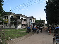
 Skyline of Mohanganj, Bangladesh | |
 | |
| Coordinates: 24°52′N 90°58′E / 24.867°N 90.967°E | |
| Country | |
| Division | Mymensingh |
| District | Netrokona |
| Area | |
| • Total | 243.2 km2 (93.9 sq mi) |
| Population | |
| • Total | 166,421 |
| • Density | 680/km2 (1,800/sq mi) |
| Time zone | UTC+6 (BST) |
| Postal code | 2446[2] |
| Area code | 09524[3] |
| Website | http://mohongonj.netrokona.gov.bd/ |
Mohanganj (Bengali: মোহনগঞ্জ) is an upazila of Netrokona District[4] in the Mymensingh division of Bangladesh. It is one of the 10 upazilas of Netrakona district. Mohanganj is largely known as the capital of Lower Bangladesh as it is the economic heart of Lower Bangladesh generally known as Haor.
- ^ National Report (PDF). Population and Housing Census 2022. Vol. 1. Dhaka: Bangladesh Bureau of Statistics. November 2023. p. 401. ISBN 978-9844752016.
- ^ "Bangladesh Postal Code". Dhaka: Bangladesh Postal Department under the Department of Posts and Telecommunications of the Ministry of Posts, Telecommunications and Information Technology of the People's Republic of Bangladesh. 20 October 2024.
- ^ "Bangladesh Area Code". China: Chahaoba.com. 18 October 2024.
- ^ Syed Marufuzzaman (2012), "Mohanganj Upazila", in Sirajul Islam and Ahmed A. Jamal (ed.), Banglapedia: National Encyclopedia of Bangladesh (Second ed.), Asiatic Society of Bangladesh