Mohave Valley, Arizona | |
|---|---|
 | |
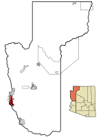
 Location in Mohave County and the state of Arizona | |
| Coordinates: 34°57′25″N 114°35′5″W / 34.95694°N 114.58472°W | |
| Country | United States |
| State | Arizona |
| County | Mohave |
| Area | |
| • Total | 14.04 sq mi (36.36 km2) |
| • Land | 14.02 sq mi (36.32 km2) |
| • Water | 0.02 sq mi (0.04 km2) |
| Elevation | 523 ft (159 m) |
| Population | |
| • Total | 2,693 |
| • Density | 192.06/sq mi (74.15/km2) |
| Time zone | UTC-7 (MST) |
| ZIP codes | 86440, 86446 |
| Area code | 928 |
| FIPS code | 04-47400 |
| GNIS feature ID | 1866989 |
Mohave Valley ('Amat' 'Analy Uuhwely[3] in Mojave) is an unincorporated community and census-designated place (CDP) in Mohave County, Arizona, United States. The population was 2,693 at the 2020 census.[2] It is geographically connected to Needles, California, Fort Mohave and Bullhead City.
- ^ "2021 U.S. Gazetteer Files: Arizona". United States Census Bureau. Retrieved May 24, 2022.
- ^ a b "P1. Race – Mohave Valley CDP, Arizona: 2020 DEC Redistricting Data (PL 94-171)". U.S. Census Bureau. Retrieved May 24, 2022.
- ^ Munro, P et al. A Mojave Dictionary Los Angeles: UCLA, 1992

