| Molescroft | |
|---|---|
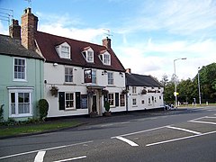
 Molescroft Inn | |
Location within the East Riding of Yorkshire | |
| Population | 6,820 (2011 census)[1] |
| OS grid reference | TA019407 |
| • London | 173 mi (278 km) S |
| Civil parish |
|
| Unitary authority | |
| Ceremonial county | |
| Region | |
| Country | England |
| Sovereign state | United Kingdom |
| Post town | BEVERLEY |
| Postcode district | HU17 |
| Dialling code | 01482 |
| Police | Humberside |
| Fire | Humberside |
| Ambulance | Yorkshire |
| UK Parliament | |
Molescroft is a village and civil parish in the East Riding of Yorkshire, England. It is situated approximately 0.5 miles (0.8 km) north-west of Beverley town centre adjoining its northern border. It lies to the north of the A1174 road and is on the eastern slopes of the Yorkshire Wolds.
The Yorkshire Coast railway line from Hull to Scarborough passes through the parish but the nearest station is Beverley.
According to the 2011 UK census, Molescroft had a population of 6,820,[1] an increase on the 2001 UK census figure of 6,810.[2] This is due to major housing developments in the north and east of the village due to unused greenfield land, firstly in the late 1990s and secondly, on a smaller scale, in the 2010s. Over 65s make up over 25% of the population,[3] higher than Under 18s. Until the early 1990s, Molescroft was very small, with the majority of the modern village being used as allotments and small farming ventures. However, housing developers saw a large, cheap area of land to place housing for the swiftly expanding Beverley. Within a decade, Molescroft grew from a small agricultural village with a population of a few hundred, to 6,810 in 2001.
- ^ a b UK Census (2011). "Local Area Report – Molescroft Parish (1170211226)". Nomis. Office for National Statistics. Retrieved 21 February 2018.
- ^ UK Census (2001). "Local Area Report – Molescroft Parish (00FB097)". Nomis. Office for National Statistics. Retrieved 1 March 2020.
- ^ "MOLESCROFT". City Population. Retrieved 6 May 2022.
