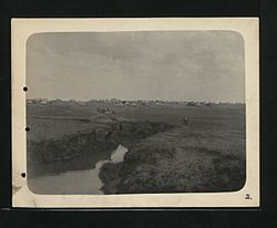
| Molopo River | |
|---|---|
 | |
 | |
| Location | |
| Country | Botswana and South Africa |
| Province | North West Province and Northern Cape |
| Physical characteristics | |
| Source | Molopo Oog |
| • location | D1337, Ottoshoop, Mahikeng Local Municipality, 2866, North West Province, South Africa |
| • coordinates | 25°53′19″S 26°1′37″E / 25.88861°S 26.02694°E |
| Mouth | Orange River |
• location | Near Augrabies Falls National Park, Northern Cape Province |
• coordinates | 28°31′02″S 20°12′46″E / 28.51722°S 20.21278°E |
• elevation | 480 m (1,570 ft) |
| Length | 970 km (600 mi) |
| Basin size | 367,201 km2 (141,777 sq mi) |
The Molopo River (Afrikaans: Moloporivier) is one of the main rivers in Southern Africa. It has a length of approximately 960 kilometres and a catchment area of 367,201 km2 with Botswana, Namibia and South Africa sharing roughly about a third of the basin each.[1]
- ^ "Review of the Molopo-Nossob Basin for Rural Communities including Assessment of National Databases at the Sub-basin Level for Possible Future Integration". Archived from the original on 2 April 2015. Retrieved 26 March 2012.
