Moncure, North Carolina | |
|---|---|
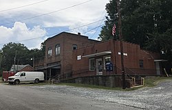
 Cluster of old buildings in Moncure; post office on the right | |
| Coordinates: 35°37′26″N 79°04′37″W / 35.62389°N 79.07694°W | |
| Country | United States |
| State | North Carolina |
| County | Chatham |
| Area | |
| • Total | 4.91 sq mi (12.72 km2) |
| • Land | 4.73 sq mi (12.25 km2) |
| • Water | 0.18 sq mi (0.47 km2) |
| Elevation | 223 ft (68 m) |
| Population (2020) | |
| • Total | 780 |
| • Density | 164.90/sq mi (63.67/km2) |
| Time zone | UTC-5 (Eastern (EST)) |
| • Summer (DST) | UTC-4 (EDT) |
| ZIP code | 27559 |
| FIPS code | 37-43880[3] |
| GNIS feature ID | 2628645[2] |
Moncure, founded in 1881, is a small rural unincorporated community in southeastern Chatham County, North Carolina, United States. Moncure and the neighboring community of Haywood form the Moncure census-designated place (CDP), which had a population of 711 at the 2010 census.[4] The community is located near the confluence of the Deep and Haw rivers, which form the Cape Fear River. Moncure once served as the westernmost inland port in the state, linked to the Atlantic Ocean by steamships.[5]
- ^ "ArcGIS REST Services Directory". United States Census Bureau. Retrieved September 20, 2022.
- ^ a b U.S. Geological Survey Geographic Names Information System: Moncure, North Carolina
- ^ "U.S. Census website". United States Census Bureau. Retrieved January 31, 2008.
- ^ "Geographic Identifiers: 2010 Demographic Profile Data (G001): Moncure CDP, North Carolina". U.S. Census Bureau, American Factfinder. Archived from the original on February 12, 2020. Retrieved December 30, 2014.
- ^ "Interesting Facts & Tidbits". County of Chatham, North Carolina. Retrieved April 23, 2012.
