Monroe County | |
|---|---|
 Monroe County Courthouse in Waterloo | |
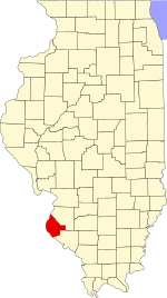
 Location within the U.S. state of Illinois | |
 Illinois's location within the U.S. | |
| Coordinates: 38°17′N 90°11′W / 38.28°N 90.18°W | |
| Country | |
| State | |
| Founded | 1816 |
| Named for | James Monroe |
| Seat | Waterloo |
| Largest city | Waterloo |
| Area | |
| • Total | 398 sq mi (1,030 km2) |
| • Land | 385 sq mi (1,000 km2) |
| • Water | 13 sq mi (30 km2) 3.3% |
| Population (2020) | |
| • Total | 34,962 |
| • Estimate (2023) | 34,957 |
| • Density | 88/sq mi (34/km2) |
| Time zone | UTC−6 (Central) |
| • Summer (DST) | UTC−5 (CDT) |
| Congressional district | 12th |
| Website | monroecountyil |
Monroe County is a county located in the U.S. state of Illinois. According to the 2020 census, it had a population of 34,962.[1] Its county seat and largest city is Waterloo.[2] Monroe County is included in the St. Louis, MO-IL Metropolitan Statistical Area. It is located in the southern portion of Illinois known historically as "Little Egypt".
- ^ "State & County QuickFacts". United States Census Bureau.
- ^ "Find a County". National Association of Counties. Retrieved June 7, 2011.


