Mont-Blanc | |
|---|---|
 | |
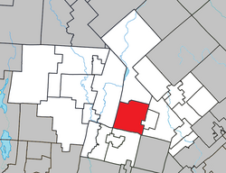
 Location within Les Laurentides RCM. | |
| Coordinates: 46°07′N 74°29′W / 46.117°N 74.483°W[1] | |
| Country | |
| Province | |
| Region | Laurentides |
| RCM | Les Laurentides |
| Constituted | January 3, 1996 |
| Name change[2] | January 29, 2022 |
| Named for | Mont-Blanc |
| Government | |
| • Mayor | Pierre Poirier |
| • Federal riding | Laurentides—Labelle |
| • Prov. riding | Labelle |
| Area | |
| • Total | 129.30 km2 (49.92 sq mi) |
| • Land | 121.28 km2 (46.83 sq mi) |
| Population (2011)[4] | |
| • Total | 3,467 |
| • Density | 28.6/km2 (74/sq mi) |
| • Pop 2006-2011 | |
| • Dwellings | 2,407 |
| Time zone | UTC−5 (EST) |
| • Summer (DST) | UTC−4 (EDT) |
| Postal code(s) | |
| Area code | 819 |
| Highways | |
| Website | mont-blanc |
Mont-Blanc (French pronunciation: [mɔ̃ blɑ̃]), is a municipality in the Laurentides region of Quebec, Canada, part of the Les Laurentides Regional County Municipality.
The municipality was formerly known as Saint-Faustin–Lac-Carré. The application to change the name to the Municipality of Mont-Blanc was approved by the Government of Quebec on January 14, 2022[2] and officially modified on January 29, 2022.[5]
- ^ Cite error: The named reference
toponymiewas invoked but never defined (see the help page). - ^ a b "Gazette Officielle du Québec" (PDF). Official Publisher of Quebec. January 29, 2022. Retrieved February 4, 2022.
J'approuve, conformément à l'article 25 de la Loi sur l'organisation territoriale municipale (chapitre O-9), en date du 14 janvier 2022, la demande de changement de nom de la Municipalité de Saint-Faustin–Lac-Carré, située dans la Municipalité régionale de comté des Laurentides, pour lui donner le nom de «Municipalité de Mont-Blanc».
- ^ a b Cite error: The named reference
mamrotwas invoked but never defined (see the help page). - ^ a b Cite error: The named reference
cp2011bwas invoked but never defined (see the help page). - ^ https://statistique.quebec.ca/statistiques/divisions-territoriales/bulletins/modifications-municipalites-janvier-2022.pdf [bare URL PDF]
