| Mont Blanc Tramway | |
|---|---|
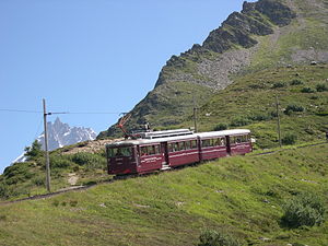
 A train of the Mont-Blanc Tramway | |
| Overview | |
| Termini |
|
| Service | |
| Type | Tramway/Rack railway |
| Operator(s) | Compagnie du Mont-Blanc |
| History | |
| Opened | 1907 |
| Technical | |
| Line length | 12.4 km (7.7 mi) |
| Number of tracks | 1 |
| Rack system | Strub |
| Track gauge | 1,000 mm (3 ft 3+3⁄8 in) |
| Electrification | 11 kV 50 Hz AC |
| Highest elevation | 2,372 m (7,782 ft) asl |
| Maximum incline | 24% |
TMB route diagram | ||||||||||||||||||||||||||||||||||||||||||||||||||||||||||||||||||||||||||||||||||||||||||||||||||||||||||||||||
|---|---|---|---|---|---|---|---|---|---|---|---|---|---|---|---|---|---|---|---|---|---|---|---|---|---|---|---|---|---|---|---|---|---|---|---|---|---|---|---|---|---|---|---|---|---|---|---|---|---|---|---|---|---|---|---|---|---|---|---|---|---|---|---|---|---|---|---|---|---|---|---|---|---|---|---|---|---|---|---|---|---|---|---|---|---|---|---|---|---|---|---|---|---|---|---|---|---|---|---|---|---|---|---|---|---|---|---|---|---|---|---|---|
 Line's heights
| ||||||||||||||||||||||||||||||||||||||||||||||||||||||||||||||||||||||||||||||||||||||||||||||||||||||||||||||||
| ||||||||||||||||||||||||||||||||||||||||||||||||||||||||||||||||||||||||||||||||||||||||||||||||||||||||||||||||


The Mont Blanc tramway or Tramway du Mont-Blanc (TMB) is a mountain railway line in the Haute-Savoie department of France. It is the highest in France and the fourth highest in Europe. It is also the only railway in France reaching over 2,000 metres above sea level.[1]
The extensive views of Mont Blanc and adjacent mountains of the Mont Blanc massif provided by the tramway make it popular with tourists. Also, mountaineers and hikers use the tramway because its stops provide the jumping off points for many trails, as well as giving access to the Refuge Nid d'Aigle close to the terminus of railway.[2] The normal alpine mountaineering route to climb Mont Blanc starts at the tramway's terminus, Nid d'Aigle, and proceeds either to an overnight stop at the Tête Rousse Hut, or at the higher Goûter Hut.[3][4]
- ^ As the second and third highest, respectively the Petit train d'Artouste and the Chemin de fer du Montenvers, are just below 2,000 metres.
- ^ "Nid d'Aigle Refuge (2372m), Massif du Mont-Blanc". www.chamonet.com. Retrieved 23 February 2016.
- ^ SummitPost Tête Rousse Hut. Retrieved 17 August 2009.
- ^ "Refuge de l'Aiguille du Goûter". www.camptocamp.org. Retrieved 23 February 2016.