You can help expand this article with text translated from the corresponding article in Italian. (October 2024) Click [show] for important translation instructions.
|
Montaione | |
|---|---|
| Comune di Montaione | |
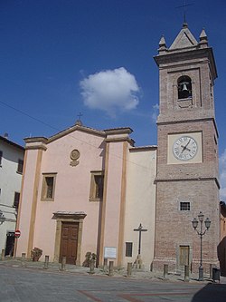
 Church of San Regolo. | |
| Coordinates: 43°33′12″N 10°54′42″E / 43.55333°N 10.91167°E | |
| Country | Italy |
| Region | Toscana |
| Metropolitan city | Florence (FI) |
| Frazioni | Barbialla, Casetta, Castelfalfi, Collegalli, Filicaja, Alberi, Iano, Sughera, Mura, Olmo, Palagio, Piaggia, Santo Stefano, San Vivaldo, Tonda, Vignale |
| Government | |
| • Mayor | Paolo Pomponi |
| Area | |
• Total | 104.8 km2 (40.5 sq mi) |
| Elevation | 342 m (1,122 ft) |
| Population (30 November 2017)[2] | |
• Total | 3,640 |
| • Density | 35/km2 (90/sq mi) |
| Demonym | Montaionesi |
| Time zone | UTC+1 (CET) |
| • Summer (DST) | UTC+2 (CEST) |
| Postal code | 50050 |
| Dialing code | 0571 |
| Patron saint | Holy Crucifix |
| Saint day | May 3 |
| Website | Official website |
Montaione is a comune (municipality) in the Metropolitan City of Florence in the Italian region Tuscany, located about 35 kilometres (22 mi) southwest of Florence. It is one of I Borghi più belli d'Italia ("The most beautiful villages of Italy").[3]


